Monday, 1 May 2017
Coastwalk
Lybster → Wick
 Distance: 17.18 miles
Ascent: 376 metres
Duration: 5 hours 39 minutes
He might return to Whaligoe
« Dunbeath | Keiss »
We had hoped to spend most of today on tracks and paths, but after being frustrated by overgrowth early on near Occumster we once again reverted to the road. Surely tomorrow we'll have more success. With a fair distance to cover, we got our heads down and paced forwards, no doubt missing plenty of spectacular coastal scenery. (Evocatively named places such as Craig a Backy and Muckle Red Craig will have to remain in our imagination.)
In all honesty missing out wasn't such a hardship, since we knew precisely where to find a remarkable feature that would more than make up for it.
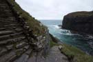
 The Whaligoe Steps aren't signposted from the road. They're also not exactly prominent on the Ordnance Survey maps either, but I've known about them and been looking forward to visiting them for years. I first came across them in Billy Connolly's World Tour of Scotland almost twenty-five years ago.
Built to service a tiny fishing harbour, 350+ steps zig-zag their way down the impossibly steep seventy-metre cliffs. My favourite story though, is of the lady who resurrected them years after harbour had been abandoned. "Since Christ was a fisherman," she reasoned, "when he comes again he might come by boat". With the steps repaired, were he to land at Whaligoe Jesus would at least be able to reach civilisation.
 Whether this comment is tongue-in-cheek or an earnest calling, the story — like the Bible verses painted on harbour walls — affirms the deep commitment to faith that still pervades this corner of our island.
Today the waves were breaking hard on the Whaligoe rocks and it was difficult to imagine anybody ever landing a boat here, let alone doing so on a regular basis.
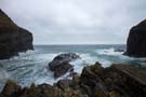
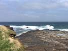
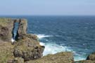 We followed the main road until just outside Wick where we finally found a reliable path to the clifftops at Old Wick Castle. The seascape here is stunning: tall cliffs pounded by the relentless sea, stacks and crags somehow resisting erosion, and slender natural arches that looked gossamer-thin.
 On the edge of the small town the path passes the Trinkie tidal swimming pool cut into the rocks, and then drops to the harbour side. We rolled our eyes at the tourist information sign that told of days when there were so many boats "you could walk from one side of the harbour to the other without getting your feet wet" — almost every coastal town seems to claim this.
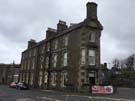 What nowhere else can claim though, is the shortest street in the world. Scarcely long enough for its signpost, Ebenezer Place is formed by the narrow doorway at the sharp end of a wedge-shaped hotel.
Wick had an air of sadness about it, but nonetheless survives. With eyes closed we could see the bustling port that it once was, when the hotels were all full and the planned town around the distillery had shops on every corner.
I can't help but think that in the era of the Digital Economy places like this would be ideal for telecommuters, but for some reason that's a revolution still to come. Perhaps I need some of that quiet faith that Wick will gain a new life.
Notes for future walkers:
- We spent most of the day on the A99, but started on local roads (ND 248 354, ND 252 357). We had tried to continue further on tracks through Mavesy but got stuck at ND 261 358 so retreated to Hillhead house and rejoined the main road at ND 257 363.
- Be sure to visit the Whaligoe Steps; access is from the end of the lane at ND 320 403 (not signposted, although the road opposite the lane is signed to the Cairn of Get).
- We left the A99 for the last time at ND 357 484, joining the coast near ND 365 480. Go to the coastal side of the fence as soon as you can.