Sunday, 30 April 2017
Coastwalk
Dunbeath → Lybster
 Distance: 12.71 miles
Ascent: 491 metres
Duration: 4 hours 34 minutes
Power of the sea
« Helmsdale | Wick »
In the interests of making forward progress we've had another day of mainly road walking. The John o' Groats Trail's splashes of white paint suggest a more coastal route across fields is possible here, but frankly we didn't have the energy for it today. So it was back to the A9, and where that headed north across the Flow Country to Thurso we stayed with the A99 coastal road.
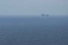 In the end it wasn't a bad choice. From the high land we could see the platforms of the Beatrice Oil Field fifteen miles out at sea, and the more recent adjacent wind farm: two very different forms of energy harvested from the wild North Sea.
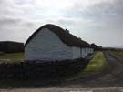 Just north of Dunbeath is the Laidhay Croft Museum, which was well worth a visit (and not only for the coffee shop). Stuffed to the rafters with artefacts of bygone crofting era, this traditional thatched Caithness Longhouse was deeply evocative, and a real change from the ruins we saw at Badbea.
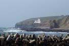
As relief from all the tarmac we made diversions to three harbours: Dunbeath near the start, Lybster at the end, and most impressively of all Latheronwheel at the halfway point (this was made all the more impressive by the stunningly beautiful strath leading to the harbour).
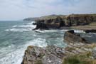 On each occasion the power of the North Sea was dramatically evident, with waves pounding against the stubborn cliffs that stood each side of the narrow harbours. It was difficult to imagine that the tide is ever sufficiently still to allow navigation, but these places were clearly central to the life of the village communities.
Notes for future walkers:
- To reach Dunbeath harbour from the top end of town, pick up a track running east from the old road at its hairpin (ND 160 295).
- A path leads back up to the A9 from between harbourside cottages at ND 163 295.
- A signposted path to Latheronwheel Harbour through Latheronwheel Strath leaves the A9 at ND 186 327.
- For a rest from the A99 we took the track south to Forse at ND 218 345; it was quite wet in places. We then followed minor roads (ND 219 342, ND 221 343, ND 222 342, ND 227 343, ND 226 349. We couldn't find a way across the Burn of Achsinegar so returned to the A99 before leaving it again at ND 231 353.
- Where the track to Achastle-shore turns west (ND 232 340), we followed white-painted marks along the clifftops all the way to the viewpoint above Lybster Bay (ND 242 344). A good path leads from there down to the harbour road.