Monday, 3 June 2013
Coastwalk
Skeffling → Easington
 Distance: 14.49 miles
Ascent: 47 metres
Duration: 5 hours 7 minutes
Under attack
« Paull Holme | Withernsea »
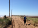
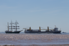
More than once already this week we've been asked, "Have you been to Spurn yet?". Today we finally reached the mouth of the Humber, and stretching out halfway across it for four miles from the northern shore is the great sand spit known as Spurn.
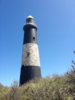 We first caught sight of the black-and-white stripes of Spurn lighthouse six walks ago from Lincolnshire. While the lighthouse was obvious, the shape of the spit was far from clear, since we were looking directly down its length. The lighthouse itself is a mile or so from the tip; the most southerly building is the blocky Humber Pilot Station.
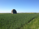
About halfway down, the spit narrows to just 30 metres of sand. The road is regularly re-routed here as the sand moves about. It's thought that in the near future there's a risk that the headland will be cut off entirely, and no doubt this would be the most likely place.
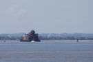 Between Spurn and the southern shore stand two forts built to protect the estuary in the First World War. Demilitarised over fifty years ago, Bull Sands Fort is being slowly being transformed into a detox centre. There are probably deep parallels to draw here.
The most surprising thing we saw beyond the narrowing was a young roe deer. If there's a herd here, they've done a very good job hiding in scant cover.
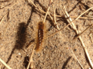 Spurn isn't just under attack from the sea though. Since 2007 it's been suffering from an overwhelming population of brown tailed moth caterpillars. At the entrance to Spurn Yorkshire Wildlife Trust posted copious notices warning visitors to keep away from the larvae, whose barbed hairs are the source of the irritation. That's easier said than done: the caterpillars carpet the headland; long trousers were definitely required.
Last year the final families that lived on Spurn left the peninsula for good. While news articles say it was the threat of being cut off that sent them further inland, I blame the moths.
 Rounding the southern end gave us a new view out into the North Sea. For the last seven walks we'd been looking out into the brown waters of the Humber, but the change of direction brought us along the deep blue of the open water and took us away from the ever-present sight of the Grimsby Dock Tower out on the near horizon. Today was a hot and tiring day - walking on the seemingly endless shingle sapped the strength in our legs - and at times it was very tempting to paddle in the surf instead.
 On the final few miles of the walk we passed one more symbol of invasion. "You can't miss the only listed building in Kilnsea," we were told as we bought ice-creams from the Blue Bell Café. The listed building is a sound mirror. I'd previously seen one on the cliffs above Folkstone. It was interesting to see another echo of the early twentieth century wars this far north.
Notes for future walkers:
- We had no trouble continuing on the sea bank after the public footpath ended at Humber Side Lane car park TA 392 171, although we did have to drop onto the beach at TA 406 162 until we reached the Crown and Anchor Inn at TA 409 157. This may be tricky at the highest of tides.
- From the Crown and Anchor another permitted path runs south-east to join Warren Road at TA 417 152.
- The walk to Spurn Point itself is easy: take the road. The footpaths on the Humber side were overgrown and not worth it.
- From the car park at TA 401 111, we descended the slipway to the beach, rounded the tip then headed back north on the sea side of the peninsula.
- About halfway back on the east side (TA 418 129), the tide squeezed us against crumbling sea defences so we clambered over the dunes to rejoin the road.
- At the northern end of the spit, we initially walked on the beach but soon climbed the low cliff and followed the clifftop to the car park at TA 417 158.
- We followed the road inland to the Blue Bell Café (good for ice creams!) at TA 415 158, then went north on the road. At TA 414 166 we took a permitted path to the west which soon turned north in front of the sound mirror and continued on the landward side of the lagoons, eventually joining New Bank to the road at TA 407 187.