Tuesday, 16 April 2013
Coastwalk
Saltfleet → Cleethorpes
 Distance: 15.7 miles
Ascent: 1225 metres
Duration: 5 hours 19 minutes
Donna Nook
« Mablethorpe | Immingham »
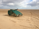
It turns out that the two military ranges which we have previously walked through this week are no longer active. That's not the case for the Donna Nook range which we walked alongside for much of today.
There's no right of way marked on the map here, and you have to walk just beyond the red danger flags, but so long as you stay outside the danger area marked with posts and notices, there is no problem.
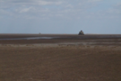
At least, there's no problem in April. In November and December it's a different story, when this entire area plays host to a huge colony of seals. We passed a number of signs telling us to stay once side of a fence, for fear of being bitten. Unfortunately there were none in sight today.
 The next obstacle is North Coates airfield. Once again there's no right of way on the sea bank, but once again we made our way without interruption. On the far side, a welcome bridge/sluice across Tetney Haven allowed us to rejoin the footpath network.
 The Environment Agency were busy throughout this section, with Heras fencing forcing us to make various adjustments to our route. The best option would've been to stick close to the dunes at all times.
Off to the east we caught our first sight of Spurn Head lighthouse, and the two early 20th century forts that guard the mouth of the Humber.
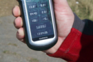
 Finally we reached Cleethorpes, but not before once more crossing the Greenwich Meridian into the western hemisphere. There are just two more crossings of the meridian on this coast path, both on the other side of the Humber.