Sunday, 2 June 2013
Coastwalk
Paull Holme → Skeffling
 Distance: 16.64 miles
Ascent: 17 metres
Duration: 5 hours 22 minutes
Landmarks
« Kingston upon Hull | Easington »
Yesterday we talked of physical landmarks. Today we crossed two invisible thresholds.
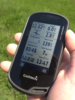
Just a few miles into the walk we reached the three thousandth mile of coast walking. (Remember: we've not been walking in order, and with a couple of gaps on the west coast yet to be completed, Gretna is somewhat more than three thousand miles behind us.) The first thousand mile mark was on the edge of Morecambe Bay on the east coast of England, the second near Hamble on the south coast; the remaining will all be in Scotland. I'm slightly disappointed we didn't engineer one of the markers to be in Wales.
As has become tradition I looked around for a suitable stone to take as souvenir of the occasion, but on finding none I instead pocketed an inch of wood that had crumbled away from a nearby fence.
 The second of today's thresholds was crossing the Greenwich Meridian for the penultimate time on the walk. With any luck we'll see it again later this week.
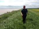
These two landmarks are the most interesting thing about the walk; the rest of the day was one long flood bank alongside the Humber estuary.
All day one landmark remained visible inland: the tower of Patrington church. Reviewing our friend John Davies' comments when he visited it a few days before Emma and I married, I feel we missed out.
If you consult a map you'll see there's no right of way for much of the north bank of the Humber. This will become a common theme for our East Yorkshire walks. This area is almost devoid of formal public access, and will likely remain so until the English Coast Path route is agreed.
 To that end, a local arm of the Ramblers Association has published a recommended route, and we are more-or-less following their path. Throughout the week we will add footnotes for future walkers describing the route we took, and any difficulties we encountered.
Notes for future walkers:
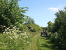
- Sunk Island is a Crown property; between Stone Creek and Outstray Farm a permissive path provides reasonable access, although it was thigh deep in thick grassy undergrowth.
- On the east side of the island, the embankment has been breached. From TA 318 180 follow the next embankment inland north-east to TA 328 189.
- Just north-west of Outstray Farm we took a track to the north-east, then turned south-west past a couple of ponds to meet up with a public footpath on Welwick Bank. A farmer was mowing the footpath here and gave us a cheery wave, so he clearly expects walkers. If only he had mown the Sunk Island path too!