Friday, 11 November 2011
Coastwalk
Barrow-in-Furness → Ulverston
 Distance: 14.3 miles
Ascent: 492 metres
Duration: 4 hours 43 minutes
Endless tarmac
« Askam in Furness | Cark »
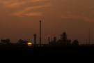
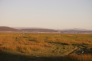
An early start cast Barrow in a new light. The streets were quiet as we tip-toed through the terraces of Salthouse before reaching the coast again on the fringes of Rooscote sands. Ahead the flares of an oil terminal beckoned the rising sun.
At the village of Rampside we declined the option to cross the causeway to Roa Island, saving a two mile there-and-back walk with the risk of being cut off by the rising tide. (We don't actually know whether or not floodwater ever rises above the road, but today wasn't the time to check. We'll visit the island another time.)
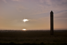
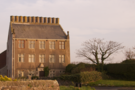
Rampside has two other places of note: the chimney-rich Rampside Hall and a curiously obilisk-like lighthouse. Both worthy of a quick snap, but little more.
Between Rampside and Bardsea the A5087 coastal road follows close to the shore. We dropped down onto the beach between Newbiggin and Aldingham, but otherwise walked in the gutter. Thankfully a true coast path picks up south of Conishead Priory, although it was narrow near the start, and passed through a waterlogged field near the end.
Finally, after skirting the edge of the Cephalosporin plant we reached the pub at Canal Foot.
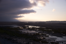
Threatening, choppy high water made contrasted with the calm we'd seen earlier in the week. It was easy to see how treacherous and deceiving Morecambe Bay can be.
We'd expected to walk back to Ulverston from here, but were delighted to find the friendliest bus I've ever been on. As we walked to our seats, everyone on board greeted us, likewise wishing us a cheery goodbye as we left. This route is threatened with closure under council spending review. For the sake of tired walkers and cheery shoppers, I sincerely hope it is spared.
Wednesday, 9 November 2011
Coastwalk
Ulverston → Cark
 Distance: 10.8 miles
Ascent: 52 metres
Duration: 3 hours 18 minutes
Speed walking
« Barrow-in-Furness | Kents Bank »
Of all the walks I've done on the coast, this is the one I recommend the least. Only two small stretches were on paths: about half a mile at the start, and another half mile one third of the way in. The rest were on roads, chiefly the A590 trunk dual carriageway, and the somewhat quieter B5278.
The traffic, the cold weather and the knowledge that rain was forecast for the afternoon combined to make this one of our fastest walks ever, averaging 3.25mph for the entire distance.
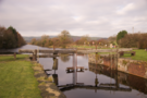
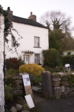
The starting point at the foot of the Ulverston Canal was by far the most scenic location of the day, with the rotting lock gates adding to its charm.
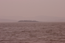
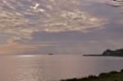 A little way out in the Leven Estuary, Chapel Island earned its tranquil name, and I couldn't help wishing - once again - for low tide and a guide across the ancient short cut to spare us from the roads. We could have been in Cark in a third of the time!
Tuesday, 8 November 2011
Coastwalk
Askam in Furness → Barrow-in-Furness
 Distance: 9.34 miles
Ascent: 71 metres
Duration: 3 hours 24 minutes
It's a secret
« Millom | Ulverston »
The blue skies have gone. We headed out this morning in a misty drizzle as the incoming tide lapped at our toes. About a mile south of Askam, Roanhead Crag looks as though it may be impassable at the highest of tides, but we just about sneaked round on the rocks.
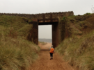
 The next three miles were wonderful on wide, sandy beaches that enclosed the dune system of Sandscale Haws. On the south-west corner of this promontory, a cluster of ramshackle buildings gave the sense that it may still be possible to scrape a living together here by fishing.
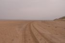
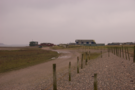 Here, with under half of the walk completed, we moved away from the shore and onto roads. We pounded the tarmac for the rest of the day.
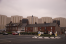
Barrow-in-Furness is dominated by its shipyards. The BAE submarine hall is visible throughout the town and beyond, towering above adjacent houses.
 On the wall of one of the shipyards is a memorial plaque. If you give the security staff your name and address they'll let you take a photograph of it. At least, that seemed to be their view of the deal. The plaque is on a public highway, and moments after snapping it they came running after me. While tempted to decline their request for details and see what the police would say, I caved in. I regret doing so; it's not clear under what authority they thought were demanding this information.
We'd hoped to walk a little further, but this incident dampened my spirit severely, so we called it quits near the town hall and made our way back to Askam by train.
Monday, 7 November 2011
Coastwalk
Millom → Askam in Furness
 Distance: 15.4 miles
Ascent: 104 metres
Duration: 5 hours 39 minutes
The Duddon Estuary
« Silecroft | Barrow-in-Furness »
The estuary of the River Duddon is another that is crossed by old rights of way. The start and end points of today's walk are joined by a three mile bridleway that crosses the sands, but in the absence of a guide we instead stuck to the shoreline and crossed on the road bridge.
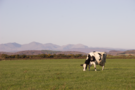
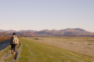 The grass on the embankment leading out of Millom was frozen from the overnight frost, but had thawed by the time we crossed the railway at Lady Hall. This first section was by far the most enjoyable with the Coniston Fells drawing us forwards.
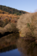 Around the head of the estuary the pavement-free busy main road was not much fun, although the view from the Duddon Bridge with the trees ablaze in autumn colours was wonderful.
Between Foxfield and Kirby-in-Furness, back lanes and paths were better, and the footpath south of Kirby initially looked promising. It soon petered out and we realised that the gully-hopping of the previous two days was just warm-up for this, the main event.
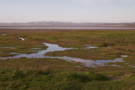
 There was no visible path. Tall rushes made it difficult to see what was underfoot, although before too long it was just one thing: deep, wet salt-marsh. Somewhere south of Soutergate Crossing we finally gave up, hopped over a fence and quickly dashed along to the footpath to Cart House. Our troubles didn't end there, as three rams refused to move away from the gate we intended to use. Ahead, a storm appeared to be closing in.
After another detour we finally rejoined the coast on the track to Dunnerholme. South of here a good path follows the edge of a golf course to the road where we'd parked the car.
Sunday, 6 November 2011
Coastwalk
Cark → Kents Bank
 Distance: 7.72 miles
Ascent: 30 metres
Duration: 2 hours 57 minutes
Meeting the Guide
« Ulverston | Grange-over-Sands »
Today got off to an inauspicious start: on leaving the station at Cark we turned the wrong way into the village, costing us half a mile's walk back to the start. We'd clearly caught a training day for a local cycling club too; we'd passed several groups on the road on the drive to Kent's Bank to catch the train, and narrowly missed being flattened by the peloton as we set off for the second time.
It's another short walk today, chiefly because trains are so hard to come by on a Sunday in south Cumbria and buses are non-existent. A secondary benefit of the plan was to slice a good few miles off an excessively long walk that we'd planned for later in the week.
What a wonderful idea that turned out to be! More gully hopping slowed us down and we took significantly longer than expected to reach Cowpren Point where a firm, wide embankment provided welcome relief.
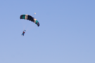 Above we heard the sound of an aeroplane slowly climbing, then the surprisingly loud fluttering of fabric unfurling as parachutes opened and brought their passengers back to earth at the North-West Parachute Centre just outside Flookborough. (Even more exciting - just opposite the airfield - is the bakery for Cartmel sticky toffee puddings.)
 East of Humphrey Head the obvious route is to follow footpaths inland to Allithwaite, then the road to Kents Bank. We instead kept to the shoreline around Kirkhead End. The going was decidedly soft (indeed in one place we seemed to be walking on a thin crust floating on a jelly of mud), but enjoyable. I imagine in the summer this would be a wonderful route.
Beyond the station in Kents Bank we continued walking towards Grange-Over-Sands, to find the place where Jon and I started the thousandth-mile of this coastwalk seven years ago. It turned out to be nearer Grange than Kents Bank, just beyond the home of Grange's most famous resident: Cedric Robinson, the Queen's Guide to the Sands.
 We knocked on the door at Guide's Farm to buy a copy of Cedric's autobiography. The man himself answered, so we chatted a while. In his role as the Guide, Cedric leads guided walks across Morecambe Bay on old rights of way between Hest Bank or Arnside and Kents Bank. I had hoped to join such a walk on this coast walk, but all organised routes run south to north while we need to walk north to south.
Cedric implied that we may be able to follow him when he's checking the route one Friday before a guided walk, so we may yet be spared the walk up and down the estuary of the River Kent as far as Levens. Watch this space next year.
Saturday, 5 November 2011
Coastwalk
Carnforth → Hest Bank
 Distance: 4.06 miles
Ascent: 6 metres
Duration: 1 hour 35 minutes
Tupping season
« Arnside | Morecambe »
We've walked one mile for every hour we spent driving today. We're heading to Cumbria to fill in another gap on the coastwalk, and loathe to "waste" a day of the holiday, I suggested we slot in a short walk on the way north, at the southernmost end of the gap.
 Most of the walk was along the fringe of a salt marsh which the recent heavy rain in the area had saturated. So the order of the day was careful hopping from tuft to tuft of grass while attempting to avoid stepping in the deep dykes.
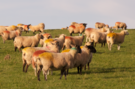
Tired of the marsh, at Red Bank Farm we instead followed a path over the low cliffs. These were densely populated with sheep, and two rams eyed us up slightly aggressively as we passed amongst their ewes. The coloured wax on the ewes backs (transferred from a ram's belly during tupping) contrasted beautifully with the lush green grass and sandy red soil.