Saturday, 30 October 2010
Coastwalk , South West Coast Path
Portscatho → Portloe
 Distance: 7.50 miles
Ascent: 599 metres
Duration: 2 hours 53 minutes
Closing the gap
« Place | Mevagissey »
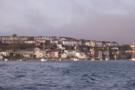
Perhaps spurred on by last night's view from Allday's fields we ignored this morning's weather forecast and set out to complete the remaining gap.
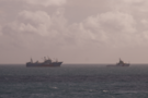
Even before the walk began we saw something of interest: FV Athena was being given a guided tour of Gerrans Bay a tug. With the fire now out the ship's being prepared for salvage. It's always interesting when a walk intersects with a national news story.
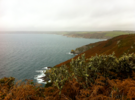
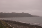
Everything we'd read online about this section of the coastpath suggested it would be a difficult stretch. It turns out that's not really the case and certainly as far as Carne Beach the easy path made for swift progress. Beyond, the ascent of Nare Head - including a sudden descent and re-ascent at Tregeagle's Hole didn't prove too difficult either (although it was certainly steep in places).
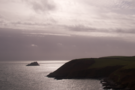
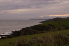
Nare Head is the last headland of the week and gave us an opportunity to survey most of the sixty miles we've walked the past few days. It's been a great week, and I suspect the speed with which we navigated the rollercoaster of the last two miles into Portloe says more about increased fitness than the quality of the path.
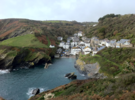
Finally we passed Broom Parc (filming location for The Camomile Lawn) and dropped into Portloe along the ridge-walk of Jacka Point and watched the thin black line of the day's route on the GPS converge with that of Thursday's walk. Zooming out the entire section from Lizard to Mevagissey was visible: another gap closed. Time to go home.
Friday, 29 October 2010
Walks
Allday's Fields
 Distance: 2.78 miles
Ascent: 132 metres
Duration: 2 days 7 hours 35 minutes
St Austell Bay
And so to Fowey again
for a few days break
in our favourite hotel
for the fifth consecutive Autumn.
We started with the traditional walk
through the town to the headland of St Catherine's.
But this time a little more: beyond to Allday's Fields.
Here we stopped in the dying light of the day.
At this point we sat and looked.
To the east Polruan with the coastpath beyond to Polperro: we've walked that.
To the west the headlands we have conquered: Gribbin, Dodman and Lizard.
Only Nare Head remains undefeated.
One day's walk. Tomorrow maybe?
Tonight we'll wrap in a warm duvet and
fall asleep to the sound of the sea and the wonky bells.
Tomorrow can wait.
Thursday, 28 October 2010
Coastwalk , South West Coast Path
Portloe → Mevagissey
 Distance: 12.1 miles
Ascent: 899 metres
Duration: 5 hours 6 minutes
Fast foward
« Portscatho | Par »
We've skipped ahead. Instead of starting today where we stopped yesterday in Portscatho, we began in Portloe - the original destination for yesterday's walk. It's a shame to leave a gap, but if this is to be the last walk of the week we wanted to end with a longer section rather than the seven miles or so between Portscatho and Portloe.
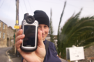
 The day didn't start too well when we realised that we had left the camera behind, so photographs are courtesy of Emma's iPhone. (Incidentally, the new HDR feature seems to work a treat in improving picture quality.)
 The central geographic feature of the walk was Dodman Point, a headland so renowned that it is addressed locally with the definite article. The Dodman has claimed many ships over the years but has neither lighthouse nor daymark. Instead its tip is adorned with a huge stone cross to honour those who strive for safety at sea.
As we rounded the Dodman, the headlands of the Lizard - and our vista of the week's walking - disappeared from view. In their place we could see Gribbin Head and its striped red and white daymark with Fowey and Polperro somewhere in the haze.
The descent into Mevagissey was welcome but ultimately slightly unsatisfactory. It had been a great walk, but was tempered slightly by the knowledge that we had still one segment left to do before we could complete the week's objective of closing the gap between Lizard and Mev.
Wednesday, 27 October 2010
Coastwalk , South West Coast Path
Place → Portscatho
 Distance: 6.11 miles
Ascent: 213 metres
Duration: 2 hours 13 minutes
Round the Roseland
« Falmouth | Portloe »
Once over the river at Place, the Coast Path picks up in the woods behind Place House, a chateau-style country house which is open to the public. The house was rebuilt in the nineteenth century on the site of an Elizabethan structure; even if you don't have time to visit Place house, it's well worth stopping to look inside the adjacent St Anthony's church.
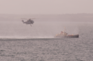 Just off St Anthony's Head, with its stumpy lighthouse, we watched what may have been a sea rescue training exercise with a helicopter winch man dangling just above a ship a short distance from the shore. Given today's news of a fire on a factory ship, it's just possible that some of this training was put into practice.
Another of the day's highlights was a brief glimpse of a pair of grey seals just off Porthbeor beach, swimming lazily in the shallow water. From a distance, they looked very like human swimmers bobbing around in the current.
Our intention had been to continue on to Portloe, but we cut the walk short at Portscatho. The latter part of the walk, with its steep climbs over rocky paths, was tiring and we knew we could make it in time for the bus from Portscatho back to St Mawes (and then ferry to Falmouth) if we stopped.
Coastwalk , South West Coast Path
Falmouth → Place
 Distance: 3.75 miles
Ascent: 1 metre
Duration: 34 minutes
Across the estuary
« Helford Passage | Portscatho »
The start of today's walk required crossing two major rivers by boat. The ferries across the Fal and Percuil rivers are sufficiently long that including them in the usual walk write-up would give a distorted picture of the actual distance travelled. This entry then just represents the ferries, plus about a quarter of a mile of walking in Falmouth.
Ferries for St Mawes leave from two different locations in Falmouth. We chose to depart from the Custom House Quay - partly because it was the nearest to our starting point, and partly because a ferry was scheduled to leave within a few minutes of us passing by.
There is another reason to visit this quay. Just behind the Custom House itself is "the King's Pipe": a furnace and chimney used for destroying contraband tobacco. It's not a particularly photogenic structure, but certainly interesting to see.
In St Mawes the ferry across the Percuil (the "Place Ferry") departed close to the point where the boat from Falmouth dropped us. Unlike the St Mawes ferry the Place ferry is seasonal, and even then may be cancelled at short notice due to adverse weather conditions. Indeed it didn't run yesterday due to high winds. The King Harry's Cornwall website provides a handy page which lists all local ferries and their up-to-the-minute running status.
Crossing the rivers provided a great start to the day, with clear views of Falmouth Docks, the huge Carrick Roads estuary (including what looked like a drilling rig) and St Mawes and Pendennis castles.
Tuesday, 26 October 2010
Coastwalk , South West Coast Path
Helford Passage → Falmouth
 Distance: 8.91 miles
Ascent: 437 metres
Duration: 3 hours 31 minutes
In the mizzle
« Coverack | Place »
Today's weather is the opposite of yesterday's. The blue skies are a murky grey and setting out from Helford Passage it's hardly possible to make out Helford village on the other side of the river.
Walking into Falmouth would be easy in fine weather, but the rain turned the path to mud and by the time we reached Cliff Road on the south side of town my feet were soaked. (Time to get new boots!)
The rain had almost stopped by the time we reached the small headland that forms the tip of the natural harbour barrier, and we had time to look at the sturdy blockhouse at Pendennis Castle. A rather charming monument stone commemorates the motorcycle races that took place on the public roads around the castle in the 1930s, although it was hard to imagine speeding down the steep roads in the wet. Further on, we were greeted by the sight of the massive cranes in the Queen Elizabeth dry dock, one of several docks at Falmouth that now offer repair and refit services to vessels from across the world.
We stopped the walk at the newly-developed Discovery Quay, now home to the National Maritime Museum, and treated ourselves to fish and chips from Rick Stein's latest eatery.
Monday, 25 October 2010
Coastwalk , South West Coast Path
Coverack → Helford Passage
 Distance: 11.5 miles
Ascent: 466 metres
Duration: 4 hours 28 minutes
Halfway round
« Lizard Lighthouse | Falmouth »
Timing was of the essence today with two rivers to cross.
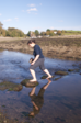 Gillan Creek has no ferry, but can be crossed on foot at low water. Most online descriptions of the route explain that the stepping stones are incredibly slippery and wading is best. What they don't make clear is that there are two river channels to cross, so that the triumphant feeling after conquering the first set of stones is soon lost when the second comes into view. Perhaps the best option is to try crossing the stones barefoot - at least that way slipping off will be a refreshing surprise rather than a disaster.
The walk ends with a crossing of the Helford River by a seasonal ferry. Unconvinced we would cover the required distance before the last boat of the day we used the GPS receiver to help us maintain a good pace that would hit the ferry.
We didn't let the pace stop us enjoying the sights on the path, for example the abandoned Dean gabbro quarries.
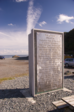 At Porthallow we stopped to look at a new monolith-like sculpture "Fading Voices" on the edge of the beach. Perhaps because of pace, we didn't realise that this is the new halfway marker that has been erected to help walkers celebrate being equidistant from both ends of the South West Coast Path. We knew that we'd encounter such a monument today, but its significance with respect to the path is inscribed on the seaward side while the path runs on the landward side. It's a shame we didn't notice; despite walking the SWCP in almost random order we too have covered about half of the distance (320 miles so far).
Sunday, 24 October 2010
Coastwalk , South West Coast Path
Lizard Lighthouse → Coverack
 Distance: 10.5 miles
Ascent: 568 metres
Duration: 4 hours 53 minutes
After a year off
« Porthleven | Helford Passage »
Three hundred and sixty days have passed since our previous coastwalk. Clearly this is why I like to try completing a segment each calendar month: not in order to collect twelve months of walking each year, but to act as a catalyst to get to the coast frequently. (It's been difficult not seeing much of the sea of late.)
Sometimes when we come away to Cornwall we just nibble at the coast. This year, with the knowledge that 2010 has been exceptionally light on coastwalking, we've decided to take a bigger bite and try to close the gap in our walking between Lizard and Mevagissey.
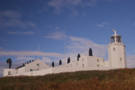
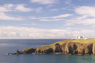 Communication was a strong theme in today's walk. We started at Lizard lighthouse which has been signalling Britain's most southerly point for over 250 years. A little further on the path was diverted from the cliff top where a new facility is being constructed for those who didn't quite get the message: a replacement lifeboat house at Church Cove.
 Throughout the walk the satellite dishes of Goonhilly Earth Station were visible inland. If you believe the taxi driver who delivered us to our starting point, these have gone silent themselves in recent months while there is an increased risk that unknown parties "out there" may misinterpret Earth's messages. Personally I suspect it's more likely another wave of BT redundancies in the face of transatlantic fibre optics.
Saturday, 16 October 2010
Coastwalk , Memories , Personal , Tech
Benoît Mandelbrot
Farewell then to another inspirational mathematician.

For much of my sixth form years I filled my spare time exploring the world of fractals. At first on paper before coding generators in Turbo Pascal on our RM Nimbus computer at home, then finally using the Fractint software (a treasure I brought back from an open day a UCL).
For first Christmas after I gave Dad a photograph of a moonscape I'd generated; it hung in his office for many years to come. (It was a cheap alternative to the hugely expensive prints being offered for sale in a shop behind Portobello Road that was dedicated to fractals.) A few months later my college invited Benoît Mandelbrot - the man who coined the term "fractal" - to give a guest lecture. Dad and I were both excited to be going.
Fractals were an important watershed for me: a connection between art, science and faith; a moment when software became "play"; a transition towards adulthood where my father an I shared a time of learning.
Of course later the notion of fractal geometry would hold another resonance: in one way my coastwalk is all about answering Mandelbrot's question of the length of the coastline of Great Britain.
So today's news is an opportunity to pause and reflect: this particular branch of maths has hooked me deeper than any other, and for that I am grateful.
Sunday, 10 October 2010
Food , Garden
Last of the garden
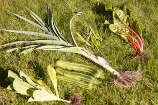
I took advantage of the warm weather today to do a final tidy of the garden. It always feels sad when the productive season ends, but we'd done well out of the small strip of garden that we dug earlier in the year: beans, leeks, blackcurrants, strawberries, potatoes, chard, lettuce and giant quantities of courgettes, along with grow-bag tomatoes and a solitary butternut squash.
Each gardening year is a learning process; this year, the tomatoes weren't as good as the previous year when I'd grown them in big tubs, but the lettuce was excellent and saved lots of money. I'm already looking forward to planning next year's planting.
Monday, 4 October 2010
South Downs Way
Washington → Amberley
 Distance: 5.69 miles
Ascent: 84 metres
Duration: 2 hours 2 minutes
In the mist
« Not walked | Not walked »
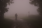
Our guide book was uncannily accurate today. It warned of a thick mist which may obscure views, and indeed most of the time we could barely see fifty metres ahead. Later a small group of walkers emerged ahead of us exactly where the book had said the would. And while at the start I scoffed at its description of seeing wisps of smoke rising from houses across the Weald I was somehow not surprise when catching a glimpse of such as we started our descent.
We'd hoped to walk much further this weekend but these three two-hour walks have had a lovely relaxing pace about them allowing us to really take in the environment, even if it was drenched or cloaked in cloud.
Sunday, 3 October 2010
Film
The First Movie

The First Movie is a film about imagination, about thought and memory. Filmed entirely in the small rural village of Goptapa in Kurdish northern Iraq, the film focuses on the lives of the village children - none of whom had ever seen a film - and their hopes and dreams.
After showing films on a make-shift outdoor screen, the director left cameras around the village to encourage the children to make movies of their own.
The results showed as much stories unique to Goptapa (the village was subjected to a chemical bombing attack by Saddam Hussein's Ba'ath regime during the Anfal campaign) as it did the themes common to us all: a hunger to live a life of love, the importance of imagination and the humour to be found in a camel's fart.
Saturday, 2 October 2010
South Downs Way
Upper Beeding → Washington
 Distance: 6.67 miles
Ascent: 164 metres
Duration: 2 hours 25 minutes
A gap in the weather
« Not walked | Not walked »
This long weekend of walking isn't going to plan. Still, we managed to get out again today even if it was only to complete the section of walking we had hoped to do yesterday.
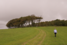
It was lovely having Mum walk with us (and provide transport!). We parked beside the recreation ground in Washington and took the bus to a point about a mile north of our staring point.
A flimsy looking camping toilet had been erected in the lay-by where we joined the path, and for the rest of the morning we passed its potential customers: Scouts who - with the help of the Sussex Downsmen - were attempting to walk up to eighty miles of the Way in a twenty-four hour period. After just two hours we were ready to stop as the rain came in again; it'd be a tough Scout who decides to continue walking into the night.
The rain didn't stop a secondary activity though. On the way back to the car a bush heavy with sloes was too good an opportunity to miss so the empty sandwich bags were soon filled with fruit which may find its way somehow into a bottle of gin.
Friday, 1 October 2010
South Downs Way
Pycombe → Upper Beeding
 Distance: 7.08 miles
Ascent: 789 metres
Duration: 2 hours 29 minutes
A very wet day
« Not walked | Not walked »
Although the South Downs Way runs through he normally-dry South, every time we've tried to walk sections of the path the weather has hampered our plans. Today was no different: rain and high winds made the walk pretty unpleasant, and we stopped short of our 13-mile target at Upper Beeding.
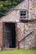
Early in the walk, the path passes Saddlescombe Farm, which is well worth a few minutes' exploration. The official guide book mentions the farm's traditional donkey-wheel, which would have provided power; part of this was visible in a boarded-out loft. But if this doesn't seem enough of a reason to stop, the farm also provides cream teas and lunches.
When we reached the road to Devil's Dyke the rain started but we foolishly plodded on, hoping it to be a passing shower. It wasn't. Three miles later and soaked to the bone we called it a day.