Wednesday, 27 October 2010
Coastwalk , South West Coast Path
Place → Portscatho
 Distance: 6.11 miles
Ascent: 213 metres
Duration: 2 hours 13 minutes
Round the Roseland
« Falmouth | Portloe »
Once over the river at Place, the Coast Path picks up in the woods behind Place House, a chateau-style country house which is open to the public. The house was rebuilt in the nineteenth century on the site of an Elizabethan structure; even if you don't have time to visit Place house, it's well worth stopping to look inside the adjacent St Anthony's church.
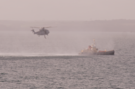 Just off St Anthony's Head, with its stumpy lighthouse, we watched what may have been a sea rescue training exercise with a helicopter winch man dangling just above a ship a short distance from the shore. Given today's news of a fire on a factory ship, it's just possible that some of this training was put into practice.
Another of the day's highlights was a brief glimpse of a pair of grey seals just off Porthbeor beach, swimming lazily in the shallow water. From a distance, they looked very like human swimmers bobbing around in the current.
Our intention had been to continue on to Portloe, but we cut the walk short at Portscatho. The latter part of the walk, with its steep climbs over rocky paths, was tiring and we knew we could make it in time for the bus from Portscatho back to St Mawes (and then ferry to Falmouth) if we stopped.
Coastwalk , South West Coast Path
Falmouth → Place
 Distance: 3.75 miles
Ascent: 1 metre
Duration: 34 minutes
Across the estuary
« Helford Passage | Portscatho »
The start of today's walk required crossing two major rivers by boat. The ferries across the Fal and Percuil rivers are sufficiently long that including them in the usual walk write-up would give a distorted picture of the actual distance travelled. This entry then just represents the ferries, plus about a quarter of a mile of walking in Falmouth.
Ferries for St Mawes leave from two different locations in Falmouth. We chose to depart from the Custom House Quay - partly because it was the nearest to our starting point, and partly because a ferry was scheduled to leave within a few minutes of us passing by.
There is another reason to visit this quay. Just behind the Custom House itself is "the King's Pipe": a furnace and chimney used for destroying contraband tobacco. It's not a particularly photogenic structure, but certainly interesting to see.
In St Mawes the ferry across the Percuil (the "Place Ferry") departed close to the point where the boat from Falmouth dropped us. Unlike the St Mawes ferry the Place ferry is seasonal, and even then may be cancelled at short notice due to adverse weather conditions. Indeed it didn't run yesterday due to high winds. The King Harry's Cornwall website provides a handy page which lists all local ferries and their up-to-the-minute running status.
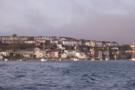
Crossing the rivers provided a great start to the day, with clear views of Falmouth Docks, the huge Carrick Roads estuary (including what looked like a drilling rig) and St Mawes and Pendennis castles.