Saturday, 19 March 2016
Coastwalk
Cruden Bay → Peterhead
 Distance: 12.14 miles
Ascent: 315 metres
Duration: 3 hours 56 minutes
Old and new
« Newburgh | Fraserburgh »
Almost exactly six months since we walked into Cruden Bay, we're back to pick up where we left off. When we were last in the area we decided that Stonehaven would be well worth another visit, and on our overnight stay here we also took in the delights of the Carron Fish Bar's infamous deep fried Mars Bar: a glistening, beige log of tooth-aching sweetness. On the "so wrong it's right" spectrum, it's heavily on the side of wrong. Culinary disappointments aside, we so much enjoyed our stay at the recently-opened Arduthie House B&B that we've booked to stay again on our way back.
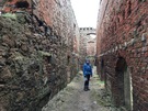
The route out of Cruden Bay quickly arrives at New Slains Castle, a Gothic hybrid of Jacobean and more recent stonework, which forms a brooding and impressive sight on the cliff edge. The mixture of ages in the building is striking, but this is a relatively recent ruin - the roof was removed in the 1920s so that the owner could avoid paying tax. Looking through the eyeless windows and empty halls, it feels as if the empty shell is waiting for its next regeneration.
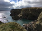 The path becomes narrow and twisting from this point, and runs very close to the cliff edge. Cliff erosion is evident at the Bullers of Buchan, a group of magnificent rock arches, stacks and sea caves, which have been carved out of the sandstone by the battering of waves and wind. In contrast to our previous visit to the area during the early autumn, the many crevices and wind-worn shelves on the Bullers were filled with nesting fulmars, kittiwakes and gulls, which form large and noisy colonies along the coast. The rocky nature of this section also makes it a good spot for watching seals: we spotted a small group in a sea cave at Yoag's Haven.
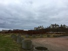 In addition to being narrow, the path is also indistinct in several places along this section, particularly between Peterhead's power station and prison. There's a sense of contrast here, too: slightly apart from the new prison building — which looks like a slightly utilitarian motel — the older disused prison building stands tall and forbidding behind a high stone wall, a grim reminder of a harsher time. It was something of a relief to arrive at the edge of the town, where the path follows a route along the edge of the harbour.
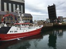 For us, Peterhead holds another point of interest: it's the most easterly point on Scotland's mainland. Sadly there seems to be nothing to celebrate this, just a raised swing bridge across to the dock buildings on Keith Inch. Then again, we didn't find anything at Lizard Point marking that out as the southernmost point of England either.
Notes for future walkers:
- The obvious route into Boddam is along the line of a disused railway. However, we found this to be waterlogged in the cuttings, and staying high on the seaward side was difficult underfoot. Eventually we gave up and walked along the A90.
- At Sandford Bay, north of Peterhead Power Station, take the path up the cliff before the water outlet; the low-level path is washed away part-way round the bay. (Besides, the overgrown walled garden of Sandford Lodge is fascinating.)
- When the road past the modern prison ends beside the South Breakwater in Peterhead, climb the cliff and walk alongside the prison boundary — the fence around the harbour makes a lower route difficult.
- The lifting bridge onto Keith Inch appears to be permanently up, so don't expect to walk round that island.