Sunday, 20 March 2016
Coastwalk
Peterhead → Fraserburgh
 Distance: 21.31 miles
Ascent: 386 metres
Duration: 6 hours 40 minutes
Turning the corner
« Cruden Bay | Gardenstown »
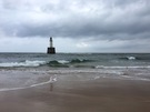
Looking at a small-scale map of Scotland, you would think it would be obvious when you've reached the north-east corner of Aberdeenshire — the point when you stop heading north, turn the corner, and start heading west. Not so. Without a doubt it lies somewhere between Peterhead and Fraserburgh but the coastline here is a long, rounded, sandy beach. About halfway between the towns there's a lighthouse at Rattray Head: we'll declare it to be the corner.
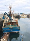
 Peterhead and Fraserburgh feel as if they need to turn a corner themselves. Although both are working ports with active industry, much of the industry is dependent on oil and the recent suppression of oil prices have had a devastating impact. The remains of the fishing industry is in decline too, with Fraserburgh's packing factories in the balance.
There are hints of the old way of life though, for example what's reputed to be Scotland's oldest salmon smokehouse near the footbridge across the River Ugie. There's also the dialect, and the memories of local people.
 At St Combs (pronounced like the hairstyling tool) we fell into conversation with a dog-walker, who told us about how the area used to be when her 'forefolk' worked the shore. Her accent was rich ("Did you come through the water?" she asked, rhyming the last word with batter) and her speech full of local Doric Scots idiom, but her warmth and expressive delivery helped to patch the holes in our understanding. When we asked how to pronounce the village name she told us that "many of the English want to put an 'oo' in"; when we mentioned that we were staying at Gardenstown this week, her eyes twinkled: "Aye, Gamrie", she nodded, referring too the village's original name.
Later the young supermarket checkout assistant in Fraserburgh greeted us with the question "Fit like?" (how are you?). It's not just the old who use Doric; the correct response would probably have been "aye, fine; yerrsel?" but instead I presented a look of bemusement. It'll take a while to tune into these colloquialisms.
Notes for future walkers:
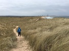
- This is a huge walk, almost entirely on a sandy beach, with few opportunities to curtail.
- We crossed the Annachie Burn on the bridge at the southern extent of the gas terminal at NK 105 531.
 There's a reasonable path just outside the gas terminal fence, used by security patrols and their alsatians!
- We crossed the outfall of Loch of Strathbeg on the bridge at NK 066 604. This is the "water" our friend asked us about, implying that it's fordable on the beach.
- From Inverallochy we followed the B9107 inland to the B9033, then took to Fraserburgh Golf Course once we'd crossed the Water of Philorth.