Thursday, 10 October 2013
Coastwalk
West Quantoxhead → Minehead
 Distance: 11.20 miles
Ascent: 221 metres
Duration: 3 hours 53 minutes
The Great Joining-Up
« Combwich | Porlock Weir »
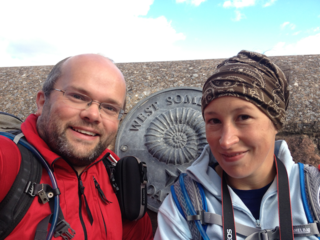
I t's a big day today: the last walk on the West Somerset Coast Path, and the last walk in the last of our "gaps". Today's the day that we connect Gretna to Whitley Bay in one long walk of three thousand, three hundred miles.
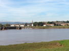
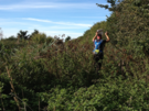
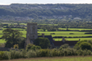
We walked on the road as far as Watchet, and as we descended into the town it was evident how different the land use is here compared with what we've seen on previous days this week. Gone are the farms and pretty hamlets, replaced by caravan parks and beach huts; this tourist country.
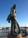 On Watchet's quay stands a statue of the Ancient Mariner, commemorating Coleridge's association with the area.
Further ahead the unmistakable bulk of Minehead's North Hill loomed ever closer. We could identify its outline from as far away as Clevedon last Saturday, so it was reassuring to see it in detail as we approached.
 All too soon we reached the outskirts of Minehead, marked by the canvas structure of the Butlins where I once attended a Spring Harvest.
A short stroll along the prom and we were at our destination: the map-in-hand sculpture that marks the start of the South West Coast Path, and the rather more modest metal disc in the prom wall that indicates the end of the West Somerset Coast Path.
It's as hard to look ahead and imagine the two thousands miles of walked path in front of us as it is to imagine the thousand miles behind us. This coastal trek certainly feels more like a sequence of short walks rather than one exceedingly lengthy one. And it's not over yet.
Wednesday, 9 October 2013
Coastwalk
Combwich → West Quantoxhead
 Distance: 18.32 miles
Ascent: 5:44 metres
Duration:
The future coast path
« Bridgwater | Minehead »
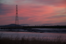
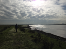
This is becoming a habit: the autumnal dawn walk. In 2011 we watched the sun rise over gas terminals near Barrow in Furness. Last year it was the post-industrial mining landscape of West Cornwall. Today we saw dawn break as we completed the last few miles of the River Parrett.
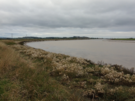
 The coast path we walked today won't be here much longer. Inland the Steart peninsula is about to be converted into a huge new wetland. Artificial river channels have been dug and before 2014 is out the bank of the Parrett will be pulled down to allow the waters to flood in. We felt privileged to be some of the last people who'll walk this path.
 We joined the West Somerset Coast Path and soon crossed another sea defence that is under threat, this time from the Bristol Port Company. The plan is to flood this second section of the Steart peninsula to compensate for land reclaimed from the sea in creating a new container terminal at Avonmouth.
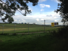 A little further on we met another change to the path. EDF plan to build a new nuclear power station at Hinkley Point, and in what appears to be a tactical move a vast area of land has been fenced off and all public rights of access revoked. We had to resort to walking just outside the perimeter fence: two miles of chain-link topped with barbed wire and adorned with copious warning notices about dogs and CCTV. A dirt road ran just inside the fence line, and as we were reaching the end we met a couple of patrols who presumably were tasked with checking we were not a threat. The whole affair made us feel uncomfortable and guilty even though we were clearly weren't.
 Beyond Hinkley we enjoyed five miles of rolling cliff tops, the path now significantly more popular than earlier in the day. The naval firing range at RNAS Lilstock was just hoisting its red flag and provided the sole diversion from the farms and hamlets. Across the Bristol Channel we could clearly make out the towns and hills of South Wales.
 Suddenly the Quantock Hills closed in on the coast and we had to take one final diversion inland. There is no formal coast path west of Quantock's Head so we joined the treacherous A39 for a final half mile into West Quantoxhead. I expect we shall return when the England Coast Path has forged its more coastal route here, but for now that is just a future coast path.
Notes for future walkers:
- We stayed on the bank of the River Parrett to ST 279 454, from which point a temporary path led us to Steart village.
- Once the seawall has been breached there will be a new path heading round the western side of the wetland from a point near ST 263 437.
- If the Bristol Port Company project goes ahead, the land seaward of Stockport Bristol may be flooded, necessitating a detour through the village.
- We found no mention of the Hinkley diversions online. The path is along the coast to the west of the current power station is closed. The diversion follows the path from ST 217 461 to the access road at 207 453. Cross the road and follow the perimeter fence, which after a loop follows the road south to ST 207 447, then west to ST 198 447 and then more-or-less north to the cliff top at ST 194 461.
Tuesday, 8 October 2013
Coastwalk
Bridgwater → Combwich
 Distance: 7.86 miles
Ascent: 70 metres
Duration: 2 hours 43 minutes
The Coastwalker
« Highbridge | West Quantoxhead »
The west bank of the Parrett is more arable than pasture, but once again the path seems rarely used. Ahead we saw a man struggling through the shin-high grasses, wet with dew. There was something familiar about his manner.
"You came prepared," he said as we met on an overgrown section of the river embankment.
As he pointed to my gaiters I saw that his legs were sodden from the wet grasses we were fighting through. At least he had trekking poles; I'd picked up a stick to help us through a field of cows earlier on.
 We exchanged pleasantries, and an unexpected moment.
"Burnham," he replied when we asked where he was headed to today. (Our short hop to Combwich seemed amateur in comparison.)
With a slightly sheepish look on his face he drew in another breath and added, "I'm walking the whole coast."
"So are we!"
Thus for the first time ever we met another coast walker. Conversation flowed swiftly as we exchanged tips about what's to come.
Our friend started five years ago in Rye and intends to take another ten years to complete all three countries. This year his plans were to walk from Sennen Cove to Chepstow, something that he felt was in jeopardy given the approaching winter.
We strode on buoyed by our encounter, delighted to have met a fellow traveller, and surprised it had taken so long.
Monday, 7 October 2013
Coastwalk
Highbridge → Bridgwater
 Distance: 12.79 miles
Ascent: 26 metres
Duration: 4 hours 16 minutes
The Parrett
« Weston-super-Mare | Combwich »
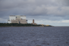
Six miles west of Highbridge stands Hinkley Point power station. The regular square blocks stood out when we first saw them towards the end of yesterday's walk. They may only be six miles away, but it'll take us a couple of days to get there, chiefly because of the main feature of today's walk: the River Parrett.
We turned our back on the sea almost as soon as we'd started walking today, heading upstream from the river mouth to its first crossing point in Bridgwater.
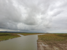
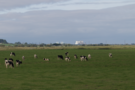
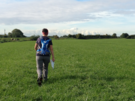
The Parrett meanders slowly across the Somerset Levels in long, sweeping bends. The path sticks firmly to the river embankment, with only the grazing sheep and cattle for company.
 We've had mixed weather today: a misty start and a drizzly end contrasted with a few moments of sunshine as we passed the village of Combwich on the opposite bank.
Judging by the large number of padlocked and otherwise unfriendly field gates, we surmise that this path isn't trod very often. It's no surprise given in places the river turned us through 180 degree loops, playing havoc with our sense of direction.
 The importance of fixed point of reference as a navigational aid became abundantly clear. Pawlett church tower is whitewashed, presumably to facilitate in this manner; the scale of the power station means that it unintentionally provides a similar service. At Dunball Wharf we were forced off the river bank, having to continue most of the way into Bridgwater on the A38, although a short distance
Notes for future walkers:
- From Dunball Wharf (ST 310 408) we had to follow the A38 south towards Bridgwater. The cycle path on the river bank shown on our map didn't exist on the ground.
- Keep an eye out for a tiny footpath running west from ST 307 387 that takes you back to the river; it's squeezed between two houses and could easily be missed.
Sunday, 6 October 2013
Coastwalk
Weston-super-Mare → Highbridge
 Distance: 15.47 miles
Ascent: 40 metres
Duration: 5 hours 15 minutes
Another day, another detour
« Clevedon | Bridgwater »
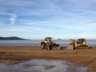
Another day, another cycle path stymied by a sluice. We'll get to that in a minute. First, bikes of an altogether noisier variety.
There were JCBs on the beach as we started this morning, gathering up the sand to create artificial dunes and obstacles for next weekend's Beach Race. Thousands of spectators will pack into the area south of the pier to watch hundreds of motorcyclists battle each other on a lengthy course that runs along the sand and into the dunes. Photographs from previous years make the race seem chaotic, a world away from the genteel-looking houses on the hill to the north of the pier.
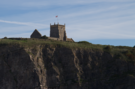 Beyond the circuit is the village of Uphill, and above the village is the disused St Nicholas' church, perched on top of a high cliff above the path.
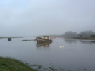
 The ferry that used to provide passage across the River Axe at Uphill sailed for the last time in the mid 1990s, so we joined a nearby cycle path to head upstream. Some maps show this route crossing the river at a sluice near Diamond Farm, but this no longer appears to be the case, so we continued another mile to cross at Wharf Farm.
 We then picked up the overgrown path to Wick Farm which was massively overgrown with nettles and dumped is in a huge field with some very skittish cattle. This wasn't the high-point of the day.
 We rejoined the roads as the Burnham Half Marathon was passing by. After yesterday's long walk the thought of only walking 13 miles seemed a luxury!
 At Brean village we turned left along the beach. We would have liked to turn right and circuit Brean Down, but that would've extended the walk by another five miles and brought us right past this same spot. We'll save it for another time.
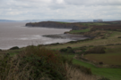
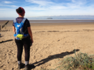
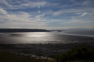
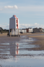 The rest of the day was on the wide, sandy beach fringed with tall dunes. Burnham provided plenty of sights, from the low, wooden lighthouse on the beach to the leaning church tower. In the distance, the twin profiles of Flat Holm and Steep Holm - small, rocky islands a few miles offshore in the Bristol channel - gradually converged; for the last two days we'd been measuring our progress along the coast by watching these two islands come into and out of view.
A short distance later we turned round the corner and were in Highbridge.
Saturday, 5 October 2013
Coastwalk
Clevedon → Weston-super-Mare
 Distance: 20.12 miles
Ascent: unknown
Duration: 6 hours 28 minutes
A tale of two piers
« Portishead | Highbridge »
We started today's walk at one pier and ended at another. They could not have been more different and between them, the route was anything but straightforward.
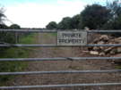 "Private" is a curious word. It can be a polite but assertive request, but when painted in black with rough capital letters on a shabby piece of wood bolted to a gate topped in curls of barbed wire, it takes on a more sinister, threatening tone. "Private" is a word that extended today's walk on three separate occasions. (We wouldn't ordinarily start a week's walking with a twenty-mile tramp.)
The trickiest point between Clevedon and Weston-super-Mare is crossing the River Yeo. The most coastal right of way that crosses it is the M5, which of course isn't an option for walkers!
In 2006 North Somerset Council expressed an intent to create The Tidal Trail: a path along sections of coast where there is presently no public right of way. Unfortunately, once the Marine and Coastal Access Act gained royal assent, the council suspended these plans, choosing to wait for Natural England to spend their money creating this path rather than spend the Council's. This is the sole negative impact of the act that I have come across.
 Sometime later, a group of local cyclists picked up the baton instead, calling for a cycle route across a sluice on the river. I've been monitoring progress for a few years now, and have reluctantly come to accept that I can wait no longer: we'd have to walk the detour.
"I don't want a cycle path," a dog-walker told us. "They come up behind you so quiet" she explained.
 So more road walking followed, then a farm track (where we found a freshly laid egg in the verge!) before crossing the motorway, diverting through an orchard and lush meadow, sneaking along an embankment, then following a right of way that a farmer had done his best to block up, and eventually back onto a road.
On the road a car kicked up a stone that struck me on the chest. Alarmed, I clasped my hand to where it hit and clearly looked sufficiently surprised that a subsequent driver stopped to check that I didn't need urgent cardiac attention!
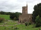
 Many lanes later we reached Woodspring Priory and another "Private" sign that kept us from exploring its grounds. Here though is a legal diversion: a small sign points east to a National Trust car park from where the headland of Middle Hope can be reached.
On the headland we met a butterfly enthusiast: a bowed old man in a black suit and a deerstalker hat. He was delighted to recount tales about the local landscape, landmarks and stories of the sea but when expounding on the butterflies to be found on the headland he was completely in his element.
 Once off Middle Hope we picked up a path along the back of Sand Bay and, ice-cream in hand, managed to at last make some swift progress.
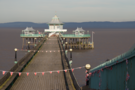
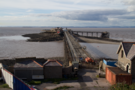 All too soon the path ended and we took to the tarmac again around Kewstoke Road past the dilapidated Birnbeck Pier to the Grand Pier at Weston.
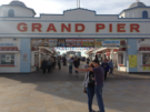 The Grand Pier is a new pier: a replacement for the one that burnt down five years ago. The replacement may be free to walk down, but it is jammed full of attention-grabbing machines and stalls, desperate to make you part with your money.
The contrast with Clevedon Pier couldn't be clearer. You may have to pay to walk the length of Clevedon's pier, but there's a simplicity and honesty about its business model: pay to visit, with no further pressure. We couldn't wait to get away from Weston.
Notes for future walkers:
- It's possible to cross the Blind Yeo on a sluice at its mouth, then follow a permissive path for a kilometre or so to ST 385 694. Don't go too far; the path continues to the end of the next field, but the only route back to the road leads from this point to the corner on Lower Strode Road between Lower and Downlais Farms.
- To cross the M5 use the bridge at ST 401 660; the apparent crossing just north of Phipp's Bridge isn't possible.
- South-west of Phipp's Bridge we managed to sneak along the embankment to the Oldbridge River, despite there being no right of way.
- The bridge over Oldbridge River at ST 390 648 was blocked by farm machinery and threatening signs, but this is a public footpath. (Payback for walking the embankment?)
- Just south of Woodspring Priory, at ST 345 660 follow the track north-east to reach a National Trust car park, then take the embankment to the north before climbing towards St Thomas's Head.
- Instead of playing chicken with cars on Kewstoke Road around Wolebury Hill it might be better to go a short distance into the woodland where a path appears to follow the road reasonably closely.