Monday, 12 March 2012
Coastwalk , South West Coast Path
Minehead → Porlock Weir
 Distance: 9.52 miles
Ascent: 254 metres
Duration: 3 hours 46 minutes
Start at the beginning
« West Quantoxhead | Lynton »
Here goes then, what is for most people their first day on the South West Coast Path is in fact our forty-fifth. It's about time we tackled the "start" of the National Trail.
A sculpture of hands gripping a map thrusts out of the promenade at Minehead, marking the official start point of what is presently Britain's longest National Trail. On the floor to the west of the monument is an arrow showing the direction of the walk. Rather pleasingly for me, there's an arrow on the east side too, pointing out the West Somerset Coast Path extending in the opposite direction. The notion of a continuous path all the way round our island appears to be gaining traction. If all goes to plan we'll be back here later in the year, having completed the Somerset leg.
Our maps showed the coast path heading through a narrow wynd and up the cliff right away. However, today we followed a more recent route, along the prom and up through the woods.
We didn't need to go very far before realising that the fog would be our companion once again. Once on top of the hill (the sole climb of the day), there was no escaping it. A "rugged, scenic, alternative path" is available but there seemed little point in us taking it today.
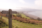 As we descended Bossington Hill the weather cleared a little and a view of the final part of the day's walk opened up: three miles along field boundaries on the fringe of Porlock Marsh.
Halfway across the marsh we found a monument commemorating the lives of a USAF crew whose plane had clipped Bossington Hill in 1942. On a day like today it's easy to see how such a mistake could have been made.
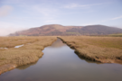 The monument also represents change. When originally erected it was located on the shingle bank at the back of the beach, but a decade or so ago a storm breached this ancient marsh wall, and since then the land management policy of the whole area has been one of managed retreat, with the sea water flooding in on each tide to create a new salt marsh. It's likely this path is impassable near high tide.
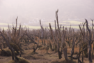 In front of the monument a strand of skeletal trees poke forlornly out of the ground, life drained out of them by the salt water.
Today's fog added understanding and atmosphere.