Tuesday, 10 September 2013
Coastwalk
Tarleton → Southport
 Distance: 16.56 miles
Ascent: 115 metres
Duration: 5 hours 35 minutes
The West Coast of Lincolnshire
« Preston | Hightown »
After yesterday's observation about the Ribble and the Humber, it's been hard today to ignore the similarities between West Lancashire and Lincolnshire. Heck, the county names even sound alike.
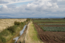
The majority of today's walking was on raised embankments cutting through sunken fields and marshland. Inland, small bands of workers were stooped behind tractors, wielding long knives to harvest tightly packed crops of cabbage, broccoli and cauliflower. Out on the marshland, sheep and cows grazed the lush meadows.
 Surprisingly, what wasn't evident was the hydraulic fracturing test bores that have caught the news recently. We must have passed within 500 metres of one of the first sites, but despite knowing its location there was no sign of the towering industrial structures we had expected. We're still undecided about the wisdom of fracking,
(We note that Lord Howell of Guildford has also recently spotted similarities between east and west in the north. He shamefully described the north-east as desolate, and then tried to dig himself out of a hole by saying he had actually meant the north-west. This is something we definitely don't agree on!)
 As the wind picked up we reached Fiddlers Ferry, the starting point of Marine Drive, a five mile coastal road leading into Southport. Here too the Lincolnshire link asserts itself with the seaside resorts situated to the south of the working fields.
 We passed by the Marine Lake, and under the elegant pier to finish our walk at the end marker of the Trans Pennine Trail, cousin to the one we stood beneath just a few months ago in Hornsea (although we don't remember that one slowly rotating as this one did).