Wednesday, 11 September 2013
Coastwalk
Southport → Hightown
 Distance: 14.14 miles
Ascent: 101 metres
Duration: 4 hours 34 minutes
On Liverpool's doorstep
« Tarleton | Liverpool »
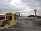
Southport is lovely. But it's not the place I first set eyes on eight years ago. Back then, as I rounded the Coast at St Anne's, roller coasters loomed on the horizon across the river. Today, the site of The Cyclone is just a bare patch of Tarmac next to a much reduced Pleasureland. Don't take the demise of the theme park as representative of the whole town though. Lord Street's colonnaded shop fronts were as busy as you'd expect of a town twice Southport's size and the bustle around the Royal Clifton Hotel shows that the tourist market hasn't completely dried up (although we seemed to be decades younger than their usual type of guest).
As the walk into town from the north ended with five miles of road, so today's walk to the south started in a similar vein. Behind the dunes to our left the map told of the Royal Birkdale Golf Club although the natural landscape screened its activities from mortals such as ourselves.
 Golf courses peppered the rest of our walk, and it's easy to see why, with towering dunes (here known as "sand hills") and wide open beaches broken only by woodland.
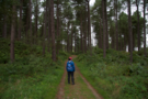 Ainsdale National Nature Reserve was the highlight of the walk. This forest is haven to the natterjack toad and the red squirrel, although we saw none of the latter and caught only a brief glimpse of what we assume to be the former.
The Merseytravel network runs frequent rail services up and down this stretch of coast, so it was no surprise to find day-trippers everywhere: some visiting Southport's shops, others enjoying the beaches while two particularly content women were filling box after box with blackberries ("We've a whole freezer-full at home," one said).
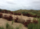 Back on the dunes another forest is taking shape: discarded Christmas trees are being used as a natural means of stabilising the sand banks.
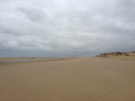 Eventually we reached Formby Point, the most westerly point on the Sefton Coast. Here at the back of the beach lie a few courses of brick: all that remains of England's first lifeboat station. Nearer the shoreline three enthusiastic souls were doing synchronised aerobics, with the Clwyddian mountains rising majestically behind them and the Great Orme off to the right.
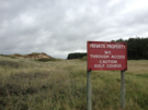
Soon we were upon the red flags and warning signs on the perimeter of the Altcar Rifle Range. It's unusual for us to pass MOD land that's actively in use so the pop-pop-pop coming from the range was a curious accompaniment to the final mile, rather than an annoyance.
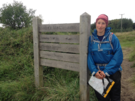 And with that we reached Hightown, the final stop on our Sefton Coast Path, and celebrated the closure of the first of three gaps we hope to plug before the year ends.