Friday, 13 September 2013
Coastwalk
Arnside → Carnforth
 Distance: 8.95 miles
Ascent: 149 metres
Duration: 3 hours 35 minutes
The unloved coast paths
« Grange-over-Sands | Hest Bank »
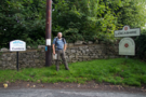
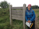
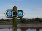
Today we crossed from Cumbria into Lancashire; we completed the Cumbria Coastal Way and picked up the Lancashire Coastal Way. Both routes were devised and described by Ian and Krysia Brodie. Both routes suffer from a distinct lack of love.
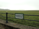
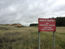
 These routes should be gems, but there's a sense that the local authorities haven't taken them to heart. It's one thing devising a long-distance route, but it needs constant support if it is to continue to thrive. Currently the signage is patchy at best, and downright misleading in places. For example, today we passed a notice that told us the path ahead was diverted. It was - back in December 1999 - but no-one had thought to remove the notice once the diversion was cleared. In other places the path has been narrow and overgrown.
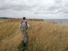
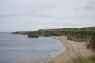
 Enough moaning! Today's walk has been delightful, particularly the stretch from Arnside to Silverdale which begins with some beach walking before rising to follow the tops of low cliffs with stunning views across the expanse of Morecambe Bay. Yesterday's mist lifted so the full panorama of the Lakeland Fells provided a stunning backdrop.
 The county boundary is near Silverdale, on the first of the day's sections of road walking.
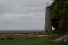
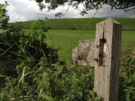
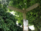 After a short spell back on the beach we followed the road again and it was at the junction of Hollins Lane and Lindeth Road that we came across the aforementioned diversion sign. It seemed to refer to the path beyond the road end near Jenny Brown's Point. We're glad we ignored it: this is a glorious spot, with an old chimney standing firm against the tide on the shoreline.
 We were soon at Crag Foot, the start of our final leg of road walking to Carnforth. Here we came across an old man who walked with a gnarly stick. "I've been walking Warton Crag for fifty years," he told us, "but found two new paths up there today." May he ever retain this delight in exploration!
Our walk finished after we crossed the River Keer just west of the town: the second of the three west coast gaps now complete. Only Somerset to go now.
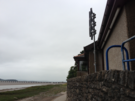
We took the train back to Arnside, and have two further activities to recommend. First, Carnforth railway station. It was here that the 1945 romance Brief Encounter was filmed, and many of the buildings have been converted into a wonderful set of museums; the tea room occupies some of the original station rooms and is decked out with plenty of film memorabilia. We could have spent hours here, especially since the volunteers running the visitor centre were so keen to chat.
Secondly, this evening as we dropped down to the river at Arnside we saw its tidal bore! Admittedly today's tide didn't make for a particularly high wave, but to see even a few centimetres of water racing upstream was quite a sight.
Thursday, 12 September 2013
Coastwalk
Grange-over-Sands → Arnside
 Distance: 17.27 miles
Ascent: 115 metres
Duration: 5 hours 55 minutes
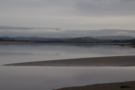
The River Kent
« Kents Bank | Carnforth »
Remember the "great walks" I was looking forward to just a few weeks ago? Grange to Arnside was due to be one of them, but in the end we couldn't take the route we'd hoped to.
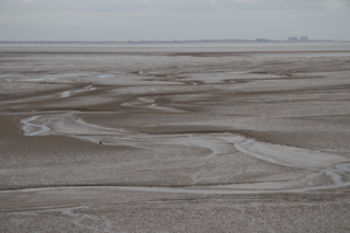
 The two villages sit on opposing banks of Morecambe Bay, and throughout the summer experienced local guides navigate tourists along the rights of way that cross the notorious quicksands of the bay. For as long as I've been planning the coast walk I've wanted to include a Bay Walk on the route, but all guided walks run from south to north, i.e. in the wrong direction. Then, at the end of August, I caught wind that this coming Sunday one guide was to "put on an event not attempted for over 30 years a walk to Grange over Sands and back again", half of which would count towards my coast walk. We were on! I booked time off work, contacted the guide and watched the weather forecast nervously. Last week though, the guide's plans changed along with the route, so we resigned ourselves to the alternative: a hike up and down the estuary of the River Kent.
 The route we took is the one described by Ian and Krysia Brodie in their book about the Cumbria Coastal Way. Describing the estuary and its scenery as "magnificent" and "superb", they enthuse that such elements "more than compensate for the bits of road walking".
I'd disagree, especially on a dreich, mizzley day like today.
 We were fortunate not to find ourselves soaked to the skin by the end of walk, but that seems to have become a theme of this week: the rain started just as we finished.
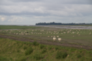
 The road walking was better than could be expected - mainly down country lanes, with plenty of berries and fruit to be foraged in the hedgerows. At a couple of farms, sparkling clean, newborn calves looked curiously at this world they had been born into. The three or four miles off the road were on sheep-grazed flood embankments that should've been perfect viewpoints for the fells, were they visible behind the mist.
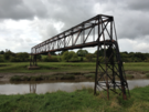
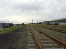
From Sandside a disused railway provided the final diversion from road walking, depositing us in Arnside beside the present railway station.
 As we headed back uphill to the Youth Hostel the stillness was broken by the wail of the bore siren, warning those still out on the sands that the tide was coming in - fast.
Wednesday, 11 September 2013
Coastwalk
Southport → Hightown
 Distance: 14.14 miles
Ascent: 101 metres
Duration: 4 hours 34 minutes
On Liverpool's doorstep
« Tarleton | Liverpool »
Southport is lovely. But it's not the place I first set eyes on eight years ago. Back then, as I rounded the Coast at St Anne's, roller coasters loomed on the horizon across the river. Today, the site of The Cyclone is just a bare patch of Tarmac next to a much reduced Pleasureland. Don't take the demise of the theme park as representative of the whole town though. Lord Street's colonnaded shop fronts were as busy as you'd expect of a town twice Southport's size and the bustle around the Royal Clifton Hotel shows that the tourist market hasn't completely dried up (although we seemed to be decades younger than their usual type of guest).
As the walk into town from the north ended with five miles of road, so today's walk to the south started in a similar vein. Behind the dunes to our left the map told of the Royal Birkdale Golf Club although the natural landscape screened its activities from mortals such as ourselves.
 Golf courses peppered the rest of our walk, and it's easy to see why, with towering dunes (here known as "sand hills") and wide open beaches broken only by woodland.
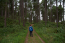 Ainsdale National Nature Reserve was the highlight of the walk. This forest is haven to the natterjack toad and the red squirrel, although we saw none of the latter and caught only a brief glimpse of what we assume to be the former.
The Merseytravel network runs frequent rail services up and down this stretch of coast, so it was no surprise to find day-trippers everywhere: some visiting Southport's shops, others enjoying the beaches while two particularly content women were filling box after box with blackberries ("We've a whole freezer-full at home," one said).
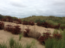 Back on the dunes another forest is taking shape: discarded Christmas trees are being used as a natural means of stabilising the sand banks.
 Eventually we reached Formby Point, the most westerly point on the Sefton Coast. Here at the back of the beach lie a few courses of brick: all that remains of England's first lifeboat station. Nearer the shoreline three enthusiastic souls were doing synchronised aerobics, with the Clwyddian mountains rising majestically behind them and the Great Orme off to the right.
Soon we were upon the red flags and warning signs on the perimeter of the Altcar Rifle Range. It's unusual for us to pass MOD land that's actively in use so the pop-pop-pop coming from the range was a curious accompaniment to the final mile, rather than an annoyance.
 And with that we reached Hightown, the final stop on our Sefton Coast Path, and celebrated the closure of the first of three gaps we hope to plug before the year ends.
Tuesday, 10 September 2013
Coastwalk
Tarleton → Southport
 Distance: 16.56 miles
Ascent: 115 metres
Duration: 5 hours 35 minutes
The West Coast of Lincolnshire
« Preston | Hightown »
After yesterday's observation about the Ribble and the Humber, it's been hard today to ignore the similarities between West Lancashire and Lincolnshire. Heck, the county names even sound alike.
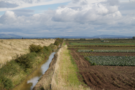
The majority of today's walking was on raised embankments cutting through sunken fields and marshland. Inland, small bands of workers were stooped behind tractors, wielding long knives to harvest tightly packed crops of cabbage, broccoli and cauliflower. Out on the marshland, sheep and cows grazed the lush meadows.
 Surprisingly, what wasn't evident was the hydraulic fracturing test bores that have caught the news recently. We must have passed within 500 metres of one of the first sites, but despite knowing its location there was no sign of the towering industrial structures we had expected. We're still undecided about the wisdom of fracking,
(We note that Lord Howell of Guildford has also recently spotted similarities between east and west in the north. He shamefully described the north-east as desolate, and then tried to dig himself out of a hole by saying he had actually meant the north-west. This is something we definitely don't agree on!)
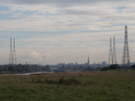
 As the wind picked up we reached Fiddlers Ferry, the starting point of Marine Drive, a five mile coastal road leading into Southport. Here too the Lincolnshire link asserts itself with the seaside resorts situated to the south of the working fields.
 We passed by the Marine Lake, and under the elegant pier to finish our walk at the end marker of the Trans Pennine Trail, cousin to the one we stood beneath just a few months ago in Hornsea (although we don't remember that one slowly rotating as this one did).
Monday, 9 September 2013
Coastwalk
Preston → Tarleton
 Distance: 12.34 miles
Ascent: 47 metres
Duration: 4 hours 18 minutes
The Ribble
« St Anne's-on-Sea | Southport »
Before we can claim to have conquered the English Coast there are a few pesky "gaps" we need to fill. This week we're taking a break from our march up the east coast and focussing on two areas in the north-west.
 For the first six miles out of Preston we followed the Ribble Way, a long distance path that follows the River Ribble from its source at Ribblehead but rather incongruously stops at a pub beside the River Douglas, some 15 miles short of the river mouth between Southport and Lytham.
 It's interesting to look across to the east from here and recognise that the Ribble is more-or-less at the same latitude as the Humber. And the coast path here certainly feels familiar, with mile upon mile of flood bank protecting low-lying farmland from the highest of tides. The Ribble is said to be the only river rising in Yorkshire which flows west, the majority of the remaining rivers ultimately joining the Humber itself.
 We pressed on beyond the end of the Ribble Way and having detoured around a footpath that itself contained a "pesky gap", crossed the Douglas to the charming village of Tarleton on the opposite bank. From the map you'd expect Tarleton to be a quiet, mostly residential place with a smattering of farm buildings. What we found was a thriving community with a bustling village high street.
Tomorrow we head back up the Douglas to follow the Ribble once more to its true end.
Notes for future walkers:
There is a pipe bridge that crosses the Douglas directly opposite Hesketh Bank. Other walkers have suggested it might provide suitable access to the village. Don't believe them. Hopefully the local council will eventually deliver on their 2008 promise for a new pedestrian bridge near here.
At SD 459 250, the path running north from Lower Marsh House stops short of the east/west path to Hall Green. Although it looks as though Access Land links the two paths, there's a dyke in the way without a bridge. We detoured via Hall Carr Lane and the footpath past Odd House Farm, although a quick trespass round the head of the dyke might be a better route.
Monday, 2 September 2013
Coastwalk
North Shields → Whitley Bay
 Distance: 7.20 miles
Ascent: 146 metres
Duration: 2 hours 48 minutes
Foiled again
« Howdon | Blyth »
Note: Five years later we walked from the Shields Ferry to the Tyne Tunnel and back (even though the pedestrian tunnels were still closed, and we had to take a shuttle bus across the river). This write-up includes the original distance from the centre of South Shields to the ferry, then across the river, even though we no longer count that part in the coastwalk.
For the second time this weekend we've been foiled in our attempt to cross a river.
Today's plan was to walk up the Tyne to the road tunnels, where a less well-known pedestrian and cycle tunnel also crosses the river. Unfortunately these are currently closed for an extended period, so rather than walk upstream to the first bridge (in Gateshead!) we took the Shields Ferry, cutting a good six miles off our walk.
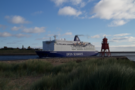 After watching sunrise from our hotel this morning, the next sight was the DFDS ferry gliding past, almost within touching distance out in the river. The compulsion to wave was strong as we saw decks lined with people freshly arrived from Amsterdam, ready to wave back.
 North Shields' history seemed close at hand, with old buildings ready to tell their stories if you'd just stop to listen. We'd heard wonders about the active Fish Quay, but it was quiet as we passed; presumably the latest catch had long since been sold on. (Maybe another day.)
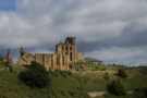 Beyond North Shields, Tynemouth with its imposing castle ruins. Beyond Tynemouth, Cullercoats and Whitley Bay — coastal resorts that seemed more upmarket than those on the south side of the river.
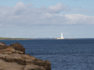 Beyond Whitley Bay we could see St Mary's Lighthouse, the turbines on Blyth harbour wall, and the shape of headlands yet to be explored. That will have to wait. For now we're heading home.
Sunday, 1 September 2013
Coastwalk
Seaham → South Shields
 Distance: 19.03 miles
Ascent: 325 metres
Duration: 6 hours 16 minutes
Surprisingly rural
« North Sands, Hartlepool | Jarrow »
"You're trespassing," said the man collecting blackberries. "So are you," I replied. He smiled as he put another handful of fruit in his carrier bag.
We knew there was no right of way along the disused railway into Sunderland, but equally we'd passed no signs telling us to keep out and had heard it was a lovely walk. Still, half a mile since joining the path we wanted to be certain there was a way out. Every time we met someone we asked the same question: is there a way out ahead?
 "You'll come to a railing; go left to a gap in the wall, jump down there. Or you could go right to the gate at the end, past the barking dog," said the boy with grubby hands.
A little further on an elderly man had set up a worktable and was painting a landscape of the backs of the adjacent warehouses on a long scroll of paper. "I'm not sure," he replied, "but be sure to walk to the very end - it's a lovely walk."
At a fork in the track we met the man with the blackberries. We gave up after talking with him. "I come here every few days," he said. "If there was a way out, I think I'd know about it. There used to be gaps all over the place, but then they put these new fences up..." He completed that sentence by gesturing at the shiny new steel fences.
We turned round. We looked at the gap the grubby boy had mentioned, but didn't fancy the nine foot drop onto the road. The artist greeted us as we passed him for the second time: "Thought you'd be back. Wonderful, isn't it?"
Yes.
 Yes, it is wonderful. That's been a theme today: unexpected beauty. From the overgrown, disused railway serving triple-duty as a playground, forager's pantry and artist's studio, to the surprisingly rural feel of the cliffs.
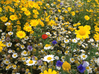
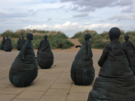
 There have been more surprises too: the wild flowers growing alongside the path at Whitburn; the curiosity of the Marsden Grotto cliff lift; the feel of the prom in South Shields, which was reminiscent of places like Brighton; the "Weeble"-like sculptures adjacent to tonight's accommodation at the mouth of the Tyne. This is a place that deserves further exploration.
 This weekend we're following Natural England's report on a proposed route for the English Coast Path in this area. The route was accepted over the summer, and will be formally opened next spring. Hopefully by that time the couple of gaps in the path north of Seaham that started our day will be reopened. We're pretty sure the railway path won't feature on the route though.