Saturday, 30 April 2011
Coastwalk , Llŷn Coastal Path
Tudweiliog → Aberdaron
 Distance: 16.8 miles
Ascent: 1106 metres
Duration: 6 hours 35 minutes
Pilgrims and Ploughs
« Morfa Nefyn | Abersoch »
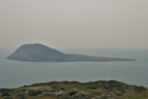
Since Caernarfon we've allegedly been following in the steps of pilgrims. The clues are there: the abundance of churches and legends. The pilgrims' destination was Bardsey (in Welsh, Ynys Enlli — the island of strong currents). The ecclesiastical heritage of this rugged island two miles off the end of the peninsula is such that it is sometimes known as the Island of 20,000 Saints.
In his narrative of Archbishop Baldwin's journey through Wales in 1188, Giraldus Cambrensis wrote of Enlli:
This island, either from the wholesomeness of its climate, owing to its vicinity to Ireland, or rather from some miracle obtained by the merits of the saints, has this wonderful peculiarity, that the oldest people die first, because diseases are uncommon, and scarcely any die except from extreme age.
It was deeply moving to consider those who have walked these paths before us over the millennia.
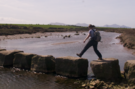
Today's long walk took us to the very end of the Peninsula, then round past Porth Meudwy - the embarkation point for the island - to Aberdaron, the most westerly village in North Wales.
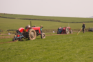 The whole walk felt as steeped in history, a sense that was heightened when we reached Anelog where the Sarn & District Ploughing Match was in full swing. One competitor was carefully measuring the distance of his furrow from his neighbour's; another drove hunched up over the wheel of his vintage tractor; others stood and looked carefully for any deviation from a straight line. There were hundreds of competitors and we really should have stopped to watch. Ploughing - along with sheep dog trialling - really should become Olympic sports.
Friday, 29 April 2011
Coastwalk , Llŷn Coastal Path
Morfa Nefyn → Tudweiliog
 Distance: 6.90 miles
Ascent: 286 metres
Duration: 2 hours 52 minutes
The village that isn't a mega-port
« Trefor | Aberdaron »
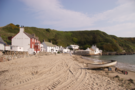
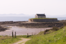
Early this morning Porthdinllaen was still. A light breeze pulled at the sea; the morning sun gave a golden hazy glow to the light. The day had a sense of possibility.
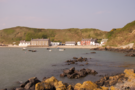 One hundred years ago this small village lost out to Caergybi as the main Welsh port for Ireland. Caergybi became heaving Holyhead while it would seem Porthdinllaen has changed very little.
After walking daily for a week it's no surprise that we decided to take it easy today, and slowly making our way along the village street, past the pub and around the rocks to the lifeboat station was the perfect tonic. A little further on three or four grey seals kept us entertained a while as we watched from the clifftops.
We stopped at the last village on the north coast, just in time to make it to the pub before the post-wedding crowd flooded in.
Thursday, 28 April 2011
Coastwalk , Llŷn Coastal Path
Trefor → Morfa Nefyn
 Distance: 11.0 miles
Ascent: 650 metres
Duration: unknown
Learning the language
« Caernarfon | Tudweiliog »
In Welsh the letter 'f' has an English 'v' sound, and since the word "tre" means "town" we had expected the correct pronunciation of the name of our starting point be "tre-vor", with a short first syllable and long second. We were wrong. It turns out the 18th century village of Yr Hendre was renamed in the 19th century after Trevor Jones, manager of the local quarry.
Coastal roads usually have a good reason for turning away from the sea. At Trefor the A499's excuse is the three-peaked mountain Yr Eifl. (Its name means "the two forks", referring to two passes that cross the massif, but the English name derived from a contraction and a transliteration is The Rivals which serves to describe the summits' competition for height rather well.)
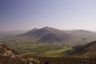 Yr Eifl has been in our sight for a long time now. Indeed it forms one of the dragon's teeth in the silhouette of the Llŷn when viewed from Abystwyth, a vista with which Emma is very familiar. It was tempting to detour to the very top but instead we sufficed with the bwlch which - having reviewed the map this evening - appears to be the highest point on the entire British coast path.
The views from the col were stunning, with Anglesey stretching out to the north, The mountains of Snowdonia to the east and the remaining teeth of the Llŷn to the west.
A mile later the path dropped steeply to the abandoned (and some say cursed) village of Nant Gwrtheryn which has in recent years been brought back to life as a Welsh language and cultural centre.
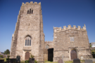
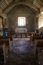 St Bueno's church in Pistyll - the next village - remains largely unchanged since an unknown hand inscribed the word 'Alleluia' and the date, 1050, above the east window. This quiet and peaceful church was originally built in the seventh century by St Bueno, one of the many Bardsey saints, and was one of the stopping-off points for pilgrims journeying to the island. Filled with foliage and flowers for Easter, there was a tangible sense of its connection with the past.
Wednesday, 27 April 2011
Coastwalk , Llŷn Coastal Path
Caernarfon → Trefor
 Distance: 18.0 miles
Ascent: 94 metres
Duration: 5 hours 47 minutes
The Llŷn
« Llanedwen | Morfa Nefyn »
 The Llŷn Peninsula Coastal Path runs for almost a hundred miles from Caernarfon to Porthmadog. We'll spend the rest of the week broadly following its route, but today we diverged significantly. For a supposedly coastal route, the Path spends most of its first twenty miles unnecessarily far inland. We chose to pick our own way, remaining as close to the sea as possible while using public rights of way.
This largely meant we walked a straight line south-west from Caernarfon on the A499. After yesterday's experience on Anglesey this was easy since there is a footpath most of the way.
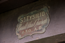
 St Beuno's church in Clynnog Fawr, towards the end of the walk, is well worth a visit. Although the main church building was constructed around 1530, it incorporates the seventh-century shrine of St Beuno, the area's patron saint. The church is surprisingly large and still has its original misericords, screen and doors; in a glass case, the medieval parish chest is preserved, now badly eaten by woodworm but still bearing massive iron straps and locks. According to the description, money made from the sale of cattle and sheep with a genetic defect in the shape of their ears was put into the parish chest, where it would most likely shared amongst the poor.
Tuesday, 26 April 2011
Coastwalk , Isle of Anglesey Coastal Path
Llanedwen → Caernarfon
 Distance: 13.5 miles
Ascent: 139 metres
Duration: 4 hours 40 minutes
Between the coast paths
« Newborough Forest | Trefor »
There were two goals for today's walk: finish our current long-distance path and walk on to the start of the next one.
The official guide to the Anglesey Coastal Path recommends taking a bus between Moel Y Don and Pwllfanogl but we felt that would be cheating so the day started with just under two miles of playing chicken with fast moving traffic on the A4080. Hopefully a new path will be constructed here in due course, but for now the book's advice is probably for the best.
 The remaining three miles of Anglesey toured the mythical "full name" of nearby Llanfair Pwllgwyngyll. The suffix -gogerychwyrndrobwllllantysiliogogogoch in fact applies only to the railway station and was a Victorian contrivance constructed by referring to features in a wide area; we passed many of these today: the rapid whirlpool - chwyrn drobwll - in the Menai Strait is the famous Pwll Ceris, also known as The Swellies; a little further on (and frankly, nearer Menai Bridge rather than Llanfair), Saint Tysilio's church - Llan Tysilio - stands peacefully on an island.
So after five miles we completed our circuit round Anglesey and Holy Island and headed across to the mainland once more. 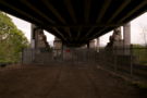 (There are two bridges across the Strait, but only one allows pedestrian access. This is a real shame since there is space on the Britannia Bridge for a walkway, either alongside the road or beneath with the railways. If recent plans for a revamped or even new crossing here come to fruition, it looks likely that pedestrian access will be allowed to Anglesey in two places.)
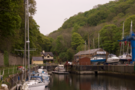 Back on the mainland private land once again forced us inland and onto main roads. This time a pavement gave us some protection on the A487 out of Bangor before we descended into Y Felinheli, taking a beautiful footpath down into the village by the dockside before crossing the swing bridge near the river mouth.
The remainder of the route into Caernarfon was along a disused railway line that has been converted to a cycle path so provided a relatively quiet end to the day.
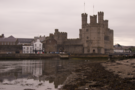
There's little that can be said about Caernarfon that can do the town justice. Finishing a walk beneath the immense castle walls reminded us of our previous visit to North Wales when we spent the best part of a day exploring this most extreme of British castles.
Monday, 25 April 2011
Coastwalk , Isle of Anglesey Coastal Path
Newborough Forest → Llanedwen
 Distance: 15.4 miles
Ascent: 269 metres
Duration: 5 hours 9 minutes
Returning to the Strait
« Rhosneigr | Caernarfon »
The end is in sight! Anglesey is often described as square in shape, and today's walk turned the final corner as once again we walked alongside the Menai Strait.
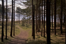 The landscape felt very different from recent walks: the open grazing on low cliffs that we have been used to was replaced first by the vast Newborough Forest and later by more formal agriculture. Although mainly pine, the forest plays host to other species as well: amongst others we saw sycamore, cherry, rowan and birch, all trying to get a secure footing in the fine sand. Information boards suggest that the red squirrel is at home here but we didn't even see a twig twitch.
We omitted the optional detour around Ynys Llanddwyn, but hope to return another day to explore this beautiful island with its lighthouse and ruined church.
 After seven miles or so we bade farewell to the forest and - after carefully crossing the stepping stones that provide a route across Afon Braint - entered farmland. Here it seemed that landowners weren't particularly fond of walkers. In addition to the usual aggressive dogs (admittedly behind fences), we were greeted with misleading signs warning of non- existent bulls and at one point a roped-off section of path.
The Anglesey Coastal Path temporarily stops at Moel Y Don since no route has been negotiated east of that point with the landowners there - a real shame when you consider one of them is the National Trust - so we headed inland to the A4080, along which our route will continue tomorrow.
Sunday, 24 April 2011
Coastwalk , Isle of Anglesey Coastal Path
Rhosneigr → Newborough Forest
 Distance: 12.7 miles
Ascent: 122 metres
Duration: 4 hours 35 minutes
Easter Sunday
« Trearddur | Llanedwen »
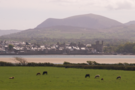
This morning started bright and warm, but the emptiness of the beach at Rhosneigr suggested that the tourists hadn't quite believed the forecast. The view from the top of Barclodiad y Gawres - a Neolithic chambered tomb in the hillside - revealed mist-shrouded mountains of Snowdonia and the Llŷn. 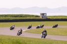 The peace was slightly shattered by the roar of motorbikes on the circuit near Trecastell; since the tide was out we took time to visit St Cwyfan's church on its tiny island offshore. Like the tomb, the church was closed; on this of all days, it would have been great to see inside.
As the day heated up, the tourists woke up: we passed streams of people heading for the beach at Aberffraw. Walking along the mile-long track on the Cob, we began to get a good view of Newborough Forest, which we'll walk through tomorrow.
Saturday, 23 April 2011
Coastwalk , Isle of Anglesey Coastal Path
Trearddur → Rhosneigr
 Distance: 15.5 miles
Ascent: 254 metres
Duration: 5 hours 46 minutes
The hungover day
« Holyhead | Newborough Forest »
Light drizzle has replaced yesterday's searing heat. The beach at Trearddur was deserted this morning, save for a few hardy dog walkers. Empty beer cans and champagne bottles were abandoned beside bins overflowing with yesterday's barbeque detritus; this foretold what the day had in store. Today was a day that didn't really get going. Holy Island and Anglesey had partied hard yesterday and to be honest, couldn't really be bothered - and perhaps neither could we.
 We walked straight past St Gwenfaen's Well thinking it was a shepherd's shelter. At Rhoscolyn navigating away from the beach seemed harder than it really should have been. A short distance later the deep watery mud which we remembered Anglesey for in March returned in force.
Four Mile Bridge should have been interesting - as the oldest of the crossings between Anglesey and Holy Island - but a series of pipes have been clamped along the side of the bridge making a decent photograph impossible.
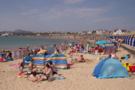
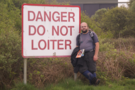 Our guidebook promised activity at RAF Valley, but even they seemed to be lying in today. To show our disdain we loitered beneath their sign that demanded otherwise. As we walked the final few metres into Rhosneigr things began to change: the sun burned its way through the clouds as holidaymakers finally decided to brave the conditions.
Looking back this would have been a tough walk to do in yesterday's weather conditions so we were pleased a little with the rain, but it's a shame that we weren't able to lift ourselves out of the subdued mood the clouds had brought with them.
Friday, 22 April 2011
Coastwalk , Isle of Anglesey Coastal Path
Holyhead → Trearddur
 Distance: 11.7 miles
Ascent: 349 metres
Duration: 4 hours 35 minutes
Holy Island
« Llanfaethlu | Rhosneigr »
On this twelve mile walk all of the excitement was compressed into a three mile section near the beginning, but first we had to get out of Holyhead.
Previously, we'd been very disparaging of this town and while that opinion remains broadly unchanged, today's optimistic sunlight gave it a hint of hope. Almost as soon as we started walking from St Cybi's church we got chatting with a lonely elderly widower who - after pointing out that he wasn't homeless - was keen to tell us of his plans for the day. Twenty yards further on, the snoring of another man laid precariously on a wall resonated round the churchyard. A mile out of town the path started to climb. It nearly reaches Anglesey's highest point but at only 220 metres' ascent the going isn't too tough. From the flanks of Holyhead Mountain the views back across Holyhead Bay were beautiful but limited by the haze. 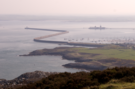 However the vast breakwater was clearly visible, winding its mile and a half out to sea, constructed from the very rock of the mountain we were standing on.
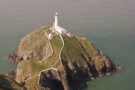
Further on we reached the highlight of the day: after a stunning mini ridge walk, the brilliant white lighthouse on South Stack island came into view far beneath us. We had intended to descend the hundred metres to cross the bridge to the island but felt that down there lay only an anticlimax; nothing could top this view.
 With about five miles walked the remainder of the day was decidedly boring. Initially we crossed open heathland reminiscent of the Suffolk coast, then later joined the lobster-red tourists laid out on the string of beaches that precede Trearddur Bay.
Near the start of the walk we saw a monument erected in gratitude to Charles, Prince of Wales. At Trearddur his son and fiancée have recently named a new lifeboat but there was no sign or acknowledgement. Is this how the monarchy has fallen from favour in fifty years?
We'll see in a week's time when this "local couple from the island" get married. It's a shame they didn't chose to use St Cybi's.
Saturday, 16 April 2011
Capital Ring
Falconwood → Wimbledon Park
 Distance: 20.3 miles
Ascent: 157 metres
Duration: 6 hours 34 minutes
South
« Not walked | Not walked »
Eltham, Mottingham, Hither Green, Beckenham, Crystal Palace, Norwood, Streatham, Tooting, Balham, Wandsworth, Wimbledon: all place names I'm familiar with, places I've visited once or twice but never really put on a map. Today that changed as we strung them all together on a long walk across the heart of south London.
There was more road walking today compared to last week's walk, and still the parks were the highlights. Two in particular stand out: the wide and varied expanse of Beckenham Place Park and the off-the-wall dinosaur sculptures in Crystal Palace Park.
 The dinosaurs really are something else. They may not be accurate according to today's understanding but that can't take away from the splendour of these hundred and fifty year old sculptures. Besides, can you think of any other Grade I listed animals?
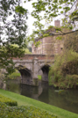
Elsewhere, country houses and palaces once again remind us that these large swathes of greenery have not always been open to all. Eltham Palace looks majestic and is a fairly recent addition to English Heritage's portfolio. Beckenham Place Park itself was only acquired by London County Council in 1927. It's hard to imagine the office of the Mayor of London making a similar acquisition today but we can live in hope.
Tuesday, 12 April 2011
Saturday, 9 April 2011
Capital Ring
Woolwich → Falconwood
 Distance: 5.7 miles
Ascent: 130 metres
Duration: 1 hour 51 minutes
East-southeast
« Not walked | Not walked »
At Christmas we walked the Jubilee Walkway, a path that approximately follows London's innermost ring-road ("The Ring"). The Capital Ring is another path that circles London, this time roughly following the route of the South and North Circular Roads. Those roads meet at the Woolwich foot tunnel, the starting point of today's walk. The tunnel itself is closed for repairs at the moment. Hopefully it'll reopen on schedule this summer, ready to carry us the final half mile of the route.
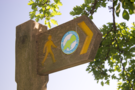
The first thing to note is how superbly the path is signposted. Although it's three quarters of a mile from Woolwich Arsenal station to the start of the walk, the signposts directing pedestrians to the route begin on the railway station platform. This was also the case for the leg from the route to Falconwood station where we finished. It's wonderful to be on a walk with such integrated public transport.
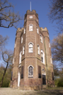 Between the start and end was a chain of parks and public spaces: riversides, formal gardens, woodland and recreation areas hosted by old follies and country houses. The highlight came just after the bizarrely named Severndroog Castle. A few paces further a distant view south from the summit of Shooter's Hill suddenly opened up showing the North Downs on the horizon.
If today's walk is representative of the rest of the Capital Ring we're about to find out just how much greenery really does enclose the city.