Friday, 25 March 2011
Tuesday, 22 March 2011
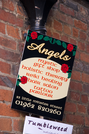
Angels
Angels, Winchester
 Angels are of course rather easy to come by in any cathedral city. Indeed there are depictions of angels in about half of the photographs we took in Winchester Cathedral on Sunday.
So here's a somewhat alternative Winchester Angel. The name of the shop ("Angels") doesn't seem to link to any of its services, but then again none of the services would ordinarily offered on the same premises either. ("Would you like a tattoo while we cut your hair? How about a mystic gift to go with that?")
Sunday, 20 March 2011
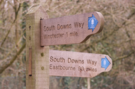
South Downs Way
Exton → Winchester
 Distance: 12.2 miles
Ascent: 229 metres
Duration: 4 hours 10 minutes
One hundred miles later
« Not walked | Not walked »
First things first: we can highly recommend Corhampton Lane Farm for bed and breakfast. Suzanne couldn't have been more helpful, picking us up from the end of our walk, ferrying us to and from The Shoe inn for an excellent meal, and dropping us back on the Way this morning. The breakfast was great too, especially the freshly laid eggs.
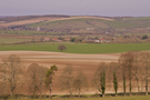
Between Exton and Winchester there's not much to write home about, although the stretch leading up to Cheesefoot Head was a delightful path meandering through copper-tinted beech trees. After the climb out of Exton, the remainder of the day was either on Tarmac roads or level chalk farm tracks. Reportedly, there are fine views of Winchester from the last few miles but today's mist obscured them.
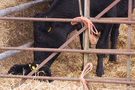 When we started this walk almost a year ago the fields were full of newborn lambs. At Lomer Farm springtime activities were well under way as we passed a pen of pregnant cows and in another enclosure the antenatal ward.
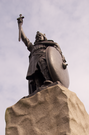 Our arrival into Winchester was abrupt and there is no marked end point of the National Trail. We chose to celebrate our completion beneath the statue of King Alfred but in all honesty you could claim the Way ends at the M3.
Winchester itself deserves a return visit. We had time to look around the stunning cathedral, but didn't get to see much else. (The Cathedral Refectory was the perfect place for a post-walk ploughman's.)
So marks the end of Paul's third and Emma's second National Trail. It's one hundred miles between Eastbourne and Winchester and we both thoroughly recommend it, although truth be told the eastern section is better than the west. Now our attention turns to completing the other three Trails we have on the go at the moment: the South-West Coast Path, the Thames Path and the North Downs Way.
Saturday, 19 March 2011
South Downs Way
Queen Elizabeth Country Park → Exton
 Distance: 10.2 miles
Ascent: 224 metres
Duration: 3 hours 36 minutes
Across the Meon valley
« Not walked | Not walked »
It's the final push for us on the South Downs Way this weekend, and we find ourselves doing something we've never done before: two day's walking, leaving the car at home and carrying everything we need on our backs. It's a liberating feeling, and something we hope to repeat a few more times in the near future.
Throughout the walk we've been puzzled by a paradox: despite being further inland than at any other time on the National Trail we've had a clear view of the sea (or at least the Solent and the Isle of Wight) all day. It's a pleasant reminder of the first day on the Downs when we rolled over the Seven Sisters.
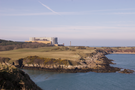
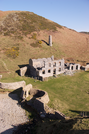
The fort on Old Winchester Hill is thought to date from Bronze Age times, but a sizeable settlement was also built here in the second century BC. Although the remains of the original burial mounds are still clearly visible, nothing remains on the ground of the many hut circles that would have filled its space. Deviating slightly from the official route, we took some time to explore the site. It gives an excellent vantage point of the plain below.
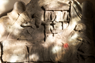 We reached Exton in plenty of time, so we stopped to look around the church of St Peter and St Paul. All the guide books draw the visitor's attention to the carving of the Angel of Death summoning The Scholar from his books, but for me the most impressive part of the interior was the stunning painted Tree of Life around the main windows in the chancel. Equally impressive - but from a practical rather than artistic standpoint - was the precarious ladder balanced on a beam running across the nave that provided access to the bell-tower. It would take nerves of steel to climb, particularly with that Angel waiting below.
Saturday, 12 March 2011
Monday, 7 March 2011
Personal
Further lessons in Welsh
Something in my DNA causes me to be fascinated by Welsh, so last week was a field trip in heaven.
On Wednesday we suffered a puncture in the car, but apart from being a slight inconvenience, it led to a treasure-trove of new words. On one side the sign outside ATS advertised its services in English. At first glance the words on the other side appeared to be impenetrable Cymraeg, but reading them aloud revealed their true genius:
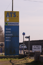
Teiars
Batris
Egsosts
Siocs
Brêcs
Tyres
Batteries
Exhausts
Shocks
Brakes
I think egsosts has just become my new favourite Welsh word. (Rollover the list above for translations.)
Sunday, 6 March 2011
Thursday, 3 March 2011
Coastwalk , Isle of Anglesey Coastal Path
Llanfaethlu → Holyhead
 Distance: 14.4 miles
Ascent: 146 metres
Duration: 5 hours 5 minutes
From one island to another
« Cemaes | Trearddur »
Parking at Llanfaethlu this morning we noticed the that Coffee House has been roped in for another duty: it is hosting the Polling Station for today's referendum.
Most of today's walk has been on tarmac, but we were still glad to be wearing boots: where we had to head inland to round the Afon Alaw the path strayed onto the edge of the marshy estuary.
The mile of walking between Llanfachraeth and Llanynghenedl was the most treacherous of the week as no pavement is provided to separate pedestrians from other road users on the busy A5025.
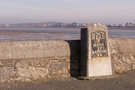
At Valley we left Anglesey on the Stanley Embankment to cross to Holy Island. The mile-long embankment was built by Telford as part of his Road to Holyhead so consequently has one of his milestones at the eastern end.
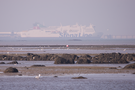
The ferries of Holyhead have been visible all day, emphasising that the town's main purpose hasn't changed since Telford's time. And indeed, the dock and railway station seem pleasant, but you don't have to look very far to see there is little by way of alternative employment for people in the town.
We finished at the official start and end of the Isle of Anglesey Coastal Path — a disappointingly nondescript plaque on the wall beside St Cybi's church in the town centre. One can only hope that similar energies to those which were found to revitalise the dock area can be invested in the rest of the community.
Wednesday, 2 March 2011
Coastwalk , Isle of Anglesey Coastal Path
Cemaes → Llanfaethlu
 Distance: 11.8 miles
Ascent: 370 metres
Duration: 4 hours 33 minutes
The community shop
« Amlwch Port | Holyhead »
It would be impossible to write up this section without mentioning Wylfa nuclear power station. Its presence just a mile outside Cemaes dominated the early part of the walk, and although decommissioning is due to start here in a year or so, we could see surveyors busy preparing for a potential second power station.

The next significant landmarks — in view since yesterday — were the Skerries, a chain of rocks a mile or two off Carmel Head, the north-west tip of the island.
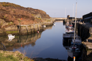
Beyond Carmel Head the landscape changed dramatically. The low, rolling cliffs of the north coast gave way to steeper, rockier headlands and inlets which slowed our progress considerably. These lasted for about two miles, and by the time we reached Church Bay their ferocity was significantly diminished.
We finished the coastal section of the walk at Porth Trwyn but the remote nature of this coast means that the nearest bus stop is a mile inland at Llanfaethlu. This is a charming village with a fantastically integrated community shop, combining café, shop, post office, hair-dresser's and village hall in a single building called the Griffith-Reade Coffee House. That said, coffee will only be back on the menu when the kitchen refit is complete.
Tuesday, 1 March 2011
Coastwalk , Isle of Anglesey Coastal Path
Amlwch Port → Cemaes
 Distance: 8.06 miles
Ascent: 377 metres
Duration: 3 hours 46 minutes
Dydd Gwyl Dewi Sant!
« Benllech | Llanfaethlu »
After the east yesterday, today we walked the bulk of the north Anglesey coast. Tomorrow we shall turn the corner again and head southwards on the west coast.
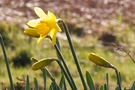
We seem to find ourselves in Wales quite often for St David's Day, although not by any particular design. Today the daffodils were doing their best to bloom in recognition of the day. Our tribute was walking past the most northerly point in the province. The true northerly point is Middle Mouse, an island just beyond the most northerly accessible point, Llanlleiana Head.
On either side of the headland are disused reminders of the area's industrial heritage. At Porth Wen an old brickworks stands defiant against the weather while to the west a porcelain works has fared less well since closure in the early 20th century.
In Welsh, Middle Mouse is known as Ynys Badraig — St Patrick's Island — and is where the saint was said to have been shipwrecked. A small church on the path just east of Cemaes was reputedly founded by him to give thanks for his safe delivery from the seas.