Monday, 28 February 2011
Coastwalk , Isle of Anglesey Coastal Path
Benllech → Amlwch Port
 Distance: 15.6 miles
Ascent: 577 metres
Duration: 6 hours 8 minutes
The east coast
« Beaumaris | Cemaes »
This walk was a classic mix of cliff tops, beaches and fields. Although there's been no rain here for a couple of days now, the ground was still very wet and we both slipped rather ungracefully at times.
Although none of the sights were familiar, most of the place names were: Moelfre, Lligwy and Amlwch all feature in photograph captions from when I was only a year or two old, the only other time I've spent more than a day on the island.
Sunday, 27 February 2011
Coastwalk , Isle of Anglesey Coastal Path
Bangor → Beaumaris
 Distance: 8.21 miles
Ascent: 202 metres
Duration: 3 hours 30 minutes
The mother of Wales
« Llanfairfechan | Benllech »
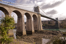
Over ten years ago, I rowed from Caernarfon to Beaumaris as one of a team of four in a Celtic longboat. Starting in the shadow of Caernafon castle, the course took us through The Swellies — a region of notoriously choppy and unpredictable water between the Britannia and Menai bridges — and on to Beaumaris. I don't remember very much about Beaumaris itself so it was a real pleasure walking over the bridge today, re-tracing part of the route inland.
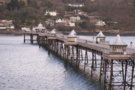 The start of the walk took us past Bangor pier, with its polished domes and wrought ironwork. From the Anglesey side yesterday, the pier almost looked long enough to reach right across the Straits.
To take a break from the road-walking we took a footpath to the southern shore of the Straits through the grounds of Bangor University. The map suggested the route would remain on the shore here but in practise it was half a mile of clambering over slippery rocks and seaweed before eventually rejoining a footpath leading back up to the road.
Down on the foreshore we got our first sight of Telford's Menai Suspension Bridge. Walking across it felt like floating across the river; birds flew beneath us as we stood to look out at the view. The significance of the bridge is noted by the fact that the village of Porthaethwy which sits beneath it on the Anglesey side is now known as Menai Bridge.
 After Porthaethwy, the coastal path took us inland to avoid the fast, winding, and pedestrian-hostile A545, favouring instead a higher route via Llandegfan and the muddy fields of Pen-y-parc before dropping us onto the edge of Beaumaris. Along the way we saw our first spring lambs, some of which were only a few days old.
Saturday, 26 February 2011
Coastwalk , Isle of Anglesey Coastal Path
Beaumaris → Benllech
 Distance: 17.4 miles
Ascent: 378 metres
Duration: 6 hours 35 minutes
Ynys Môn
« Bangor | Amlwch Port »
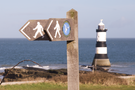
One of the tricky questions when walking round the British coast is what to do about the islands. Those without physical connections to the mainland are easy to discount, but what about those joined by a bridge — or in Anglesey's case two bridges? For this, the largest Welsh island, the answer was clear: it had to be included. Ever since my childhood I've scowled at maps of Wales that omit the island or its twin, Holy Island, so there was no way I could leave it off my map of Britain.
There's a complete coast path around the island so we'll be following that. The official guide starts the walk at Holyhead, but since we're staying at Beaumaris for a week, the obvious first walk was to start at our front door.
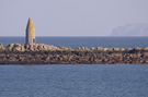
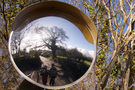
Two things will provide the lasting memories of today's walk: Penmon Priory and Red Wharf Bay.
 Walking with Emma means I stop to look more, and Penmon Priory was certainly worth lingering at.
Local wisdom has it that religious communities were founded on opposite sides of the island — St Seiriol at Penmon and St Cybi at Holyhead. They were said to walk each week to the centre of the island to meet by a wall. Since St Cybi walked west during the morning and east during the afternoon, he always had the sun on his face and became known as "Cybi the dark" while St Seiriol, who had the sun on his back, became "Seiriol the fair". We'll take more than a day to get to Holyhead but hopefully we'll make it before the end of the week.
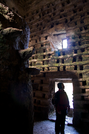
Just outside the priory is an intriguing dovecote capable of housing nearly a thousand birds. In its centre a twelve foot stone column accessed by a precarious helix of stepping stones provides a platform for ladder access to the recesses.
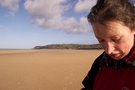
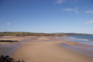
After passing the headland at Trwyn-Du the walk descended to the sands of Red Wharf Bay. Here Emma was unimpressed with my route-finding. Going against the advice of the guidebook I suggested we walk across the sands. This added at least two miles to our journey as we had to turn back when we came across a water channel that was too risky in my leaky boots.
Monday, 14 February 2011
Coastwalk , Thames Path
Tower of London → Island Gardens
 Distance: 5.14 miles
Ascent: unknown
Duration: 1 hour 25 minutes
The Dogs
« The Dome | North Woolwich »
Having crossed Tower Bridge I sat and examined my feet. Emma's other spare boots had also failed to live up to my hopes and blistered both my ankles. Although tempting to stop now I had time to kill so continued another five miles downstream to the end point of the Thames Path National Trail's north bank route through London. (Give the boots some credit: despite the blisters I completed this walk without much discomfort.)
Coastwalk
The Dome → Tower of London
 Distance: 8.02 miles
Ascent: unknown
Duration: 2 hours 12 minutes
Crossing the river
« Greenhithe | Island Gardens »
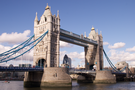
As soon as I'd decided to "walk out" the Tilbury ferry, the next decision to make was where to cross The Thames. Three tunnels can be used by pedestrians: the foot tunnels at Woolwich and Greenwich, and perhaps surprisingly the Rotherhithe road tunnel. The Woolwich tunnel was closed for refurbishment when I passed it on my previous walk, as was the Greenwich tunnel today. And although I'd quite like to walk through the Rotherhithe tunnel (despite the fumes), it's not exactly definitively London. Besides, I'm just a little bit in love with Tower Bridge.
Decision made: I'd cross on London's most photographed bridge.
The Dome is on the rather grandly renamed Greenwich Peninsula, a name that has delusions of grandeur. Interpretive signs explaining the river's history imagine that they sit on wide tree-lined boulevards between the water and beautiful apartments. Instead the vandalised notices face a grotty path on the fringes of land that is waiting for a property boom. (The sense is that it has been waiting a very long time.)
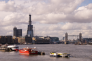
After Greenwich the path heads north, following the great U-bend in the river past a city farm along many wharves and through countless apartment blocks. Eventually, from Rotherhithe the view opens up and Tower Bridge can be seen for the first time.
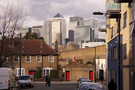
Right now though, there is one more significant element on the horizon: the Shard. From this distance the scale of this project becomes clear. It dwarfs the bridge and mocks the buildings of the City - edifices that today we laughably call sky-scrapers, but tomorrow will just refer to as office blocks.
Saturday, 12 February 2011
Chilterns and Thames Valley
Testing the boots
 Distance: 3.66 miles
Ascent: 94 metres
Duration: 1 hour 17 minutes
Walk 3: Watlington Hill
The revelation came in a branch of Cotswold Outdoor: when it comes to walking boots I may to go up a size. Coincidentally that's the size of both pairs of boots that Emma has struggled with over the years. So the goal of today's walk wasn't to get any distance under our feet, but rather to go up and down a hill to test how Em's old Scarpas fit my feet.
The answer is: not bad, but not perfect.
As for the walk, Watlington Hill was pleasant enough. From the car park at the top we headed down to The Ridgeway which skirts the foot of the ridge. After a short distance we climbed back up through the beech woods to the top.
Everywhere there were signs of nature bursting back into life: buds on tree branches and shoots tentatively poking their heads out of the earth. Spring may not be here yet, but it's certainly on its way.
Sunday, 6 February 2011
Jubilee Walkway
Jubilee Loops
Since the original Silver Jubilee Walkway was drawn up, it has been augmented by three additional "loops". Today we walked each one.
 Distance: 1.65 miles
Ascent: 26 metres
Duration: 31 minutes
Jubilee Loop
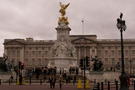
The least interesting of the three loops, the Jubilee Loop is nothing more than a circuit of St James's Park. There were still new things to see though, for example the statue of Queen Elizabeth the Queen Mother now joining that of her husband, King George VI on The Mall.
 Distance: 4.3 miles
Ascent: 74 metres
Duration: 1 hour 20 minutes
Camden Loop
The Camden Loop is the longest of the three, and in many ways the most interesting. This was an hour and a half meandering through a London we didn't know at all yet still within the Circle Line. The walk began at King's College on Chancery Lane where a plaque commemorates the completion of the original Silver Jubilee Walkway.
 Distance: 2.17 miles
Ascent: 44 metres
Duration: 28 minutes
City Loop
Finally we completed the City Loop. About half of this walk was on the raised walkways around the Barbican, while the remainder was at ground level between St Paul's and The Bank.
The theme shared by all three walks was surprise. On each we turned a corner to catch sight of a new gem that we'd not noticed before. Like the main Walkway, these are three walks to savour at leisure.