Saturday, 26 February 2011
Coastwalk , Isle of Anglesey Coastal Path
Beaumaris → Benllech
 Distance: 17.4 miles
Ascent: 378 metres
Duration: 6 hours 35 minutes
Ynys Môn
« Bangor | Amlwch Port »
One of the tricky questions when walking round the British coast is what to do about the islands. Those without physical connections to the mainland are easy to discount, but what about those joined by a bridge — or in Anglesey's case two bridges? For this, the largest Welsh island, the answer was clear: it had to be included. Ever since my childhood I've scowled at maps of Wales that omit the island or its twin, Holy Island, so there was no way I could leave it off my map of Britain.
There's a complete coast path around the island so we'll be following that. The official guide starts the walk at Holyhead, but since we're staying at Beaumaris for a week, the obvious first walk was to start at our front door.
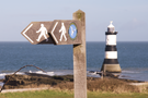
Two things will provide the lasting memories of today's walk: Penmon Priory and Red Wharf Bay.
 Walking with Emma means I stop to look more, and Penmon Priory was certainly worth lingering at.
Local wisdom has it that religious communities were founded on opposite sides of the island — St Seiriol at Penmon and St Cybi at Holyhead. They were said to walk each week to the centre of the island to meet by a wall. Since St Cybi walked west during the morning and east during the afternoon, he always had the sun on his face and became known as "Cybi the dark" while St Seiriol, who had the sun on his back, became "Seiriol the fair". We'll take more than a day to get to Holyhead but hopefully we'll make it before the end of the week.
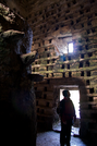
Just outside the priory is an intriguing dovecote capable of housing nearly a thousand birds. In its centre a twelve foot stone column accessed by a precarious helix of stepping stones provides a platform for ladder access to the recesses.
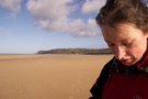
After passing the headland at Trwyn-Du the walk descended to the sands of Red Wharf Bay. Here Emma was unimpressed with my route-finding. Going against the advice of the guidebook I suggested we walk across the sands. This added at least two miles to our journey as we had to turn back when we came across a water channel that was too risky in my leaky boots.