Saturday, 22 January 2011
South Downs Way
Amberley → Cocking
 Distance: 11.9 miles
Ascent: 419 metres
Duration: 4 hours 13 minutes
Remnants of history
« Not walked | Not walked »
Today's walk started at Amberley, on the flood plain of the River Arun, taking a detour from the route published in the South Downs guide book. There was plenty of evidence if flooding, with standing water in the fields, and it wasn't long before we started to experience the effects of the recent heavy rain on the state of the path, large parts of which were both muddy and slippery.
Despite the mud, this section of the path has a lot to offer. Rising to the highest point on the Downs, it's possible to see beyond Chichester out to sea, and across to the Weald. Further on, the route joins Stane Street, a Roman trading route, and passes a number of Neolithic barrows and earthworks. More than any other section, this part of the Way reminds walkers that these are very well-trodden routes.
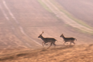
It's a route not only trodden by human feet: twice today our way was crossed by a herd of deer. Perhaps the cold weather had forced them to be more brazen, but this was the first time we'd encountered any at such close quarters.