Friday, 28 January 2011
Coastwalk
Greenhithe → The Dome
Distance: 22.8 miles
Ascent: 192 metres
Duration: 6 hours 19 minutes
The familiar
« Gravesend | Tower of London »
And so the plan for completing a coastwalk each month in the year starts again.
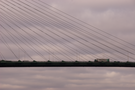
From my first steps at Greenhithe this morning I expected to see familiar sights all day. Within the first mile I passed beneath the Queen Elizabeth II Bridge at Dartford. It's a bridge I know well and has never ceased to impress in terms of scale yet from below the proportions seem to double.
Although walking across the bridge is not permitted, it is possible for pedestrians to cross the river at this point by presenting themselves to Tunnel/Bridge Control who will drive them to the other side for free. Since my intent is to walk around our island I decided to continue upstream until I was able to cross on my feet.
Leaving the bridge behind I anticipated a view of London's skyscrapers would pull me forwards for the rest of the day but that didn't emerge until I reached Woolwich much later.
Instead I found something far more interesting: the Crossness Pumping Station is a beautiful building sadly separated from the path by an eight foot steel fence. Disused for the past fifty years, it is currently being restored by volunteers and would appear to be a fascinating detour for an hour or two. If only that steel fence wasn't there.
Woolwich has a foot tunnel which is the furthest downstream that pedestrians can cross the river under their own steam. Having walked this far upstream I decided to ignore it - and the other two tunnels I will encounter that are open to pedestrians (Greenwich and Rotherhithe). I will cross the next bridge: Tower Bridge.
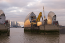
I had hoped to reach the bridge today, but as I rounded the Millennium Dome the sun had already set and my feet were sending me a very strong signal to stop.
Notes for future walkers:
- The River Darent cannot be crossed at its confluence with the Thames; the alternative is a four mile walk to the A206.
- The route is along the riverbank all the way except for a tiny diversion east of Erith, and a longer one to avoid a private industrial estate between Woolwich and the Thames Barrier.
- On parts of this walk I felt a little unsafe, with significant stretches where the way was totally hidden from view. I encountered no trouble, but never felt completely relaxed.
Sunday, 23 January 2011
South Downs Way
Cocking → Queen Elizabeth Country Park
 Distance: 13.0 miles
Ascent: 454 metres
Duration: 4 hours 35 minutes
Listen
« Not walked | Not walked »
Two contrasting sounds accompanied us today, one from below and one from above.
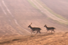
During the morning every few minutes shots range out from the double-barreled guns of a hunting party in the woods below the escarpment. I imagine pheasant was their main target, but the local deer were taking no chances when we saw them again scurry out of the undergrowth.
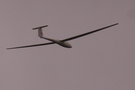
Lunchtime brought a definite end to hostilities. And with it our second sound: the whispering whoosh of a glider as its pilot played with the thermals lifting from the edge of the hill.
At Harting Down the glider was joined by radio controlled planes from a local club and the downland filled with familes out for an afternoon stroll.

Beyond the car park we were soon on our own again, imagining other sounds. Recently the path had been closed here to allow tree felling to take place. Looking at the stunning patterns of the remaining stumps you could almost hear the tree's last breath.
And then once more came the families as we entered the Queen Elizabeth forest where we ended the walk: cries of joy from children running in the woods; cries of concern from a baby whose bicycle trailer was bumping about rather too much on the cobbles.
We had hoped to bump into Mum on the final mile but signposting in the forest wasn't in our favour so settled down at the visitor centre to wait for her while drinking a cup of tea. Here now were the familes at rest: exhausted after an afternoon's play. I'd not previously been aware of QECP, but would now highly recommend it for a peaceful (but noisy) day out.
Saturday, 22 January 2011
South Downs Way
Amberley → Cocking
 Distance: 11.9 miles
Ascent: 419 metres
Duration: 4 hours 13 minutes
Remnants of history
« Not walked | Not walked »
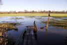
Today's walk started at Amberley, on the flood plain of the River Arun, taking a detour from the route published in the South Downs guide book. There was plenty of evidence if flooding, with standing water in the fields, and it wasn't long before we started to experience the effects of the recent heavy rain on the state of the path, large parts of which were both muddy and slippery.
Despite the mud, this section of the path has a lot to offer. Rising to the highest point on the Downs, it's possible to see beyond Chichester out to sea, and across to the Weald. Further on, the route joins Stane Street, a Roman trading route, and passes a number of Neolithic barrows and earthworks. More than any other section, this part of the Way reminds walkers that these are very well-trodden routes.
It's a route not only trodden by human feet: twice today our way was crossed by a herd of deer. Perhaps the cold weather had forced them to be more brazen, but this was the first time we'd encountered any at such close quarters.
Sunday, 9 January 2011
Chilterns and Thames Valley
Memorials and Monuments
 Distance: 7? miles
Ascent: unknown
Duration: 3 hours 30 minutes
Walk 18: Runnymede and Windsor Great Park
Emma has new boots. I do not. Mine have an ever-widening hole between the upper and the sole.
The good news is that the new boots are perfectly waterproof. The other good news is that my toes are capable of determining the temperature of freezing water when they come into contact with it.
To say today's walk is all about memorials and monuments wouldn't be quite true, but that's certainly the prevailing memory of it. In fact, the three significant monuments at Runnymede - the JFK memorial, the Magna Carta Monument and the Air Forces Memorial - all came within the first two miles of the walk. From Runnymede to The Great Park there was little of interest, but of course once inside the park itself the sense of history returns, culminating with the view from the Copper Horse statue on Snow Hill back down the Long Walk to the Castle.
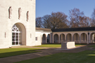
The most memorable of all these was the Air Forces Memorial. Built in the shape of a cloister, this monument has the names of over twenty thousand servicemen and women of whom no remains were found. It felt somehow fitting that from the rooftop terrace we watched aeroplanes take off at Heathrow destined for the home nations of so many of those commemorated here.
Saturday, 8 January 2011
Memories , Personal
A generation later
Here's a photograph from twenty years ago, back when the extended Bennett family used to get together every Christmas:
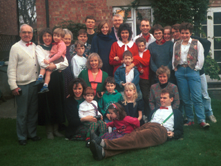
We don't meet annually anymore. That tradition stopped once Grandma and Granddad died.
But today - thanks to Rach's hard work - the full clan got back together:
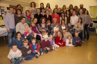
Four people from the first photograph have died, but we've gained rather more to make up the numbers.
I'm not sure we should do this every year, but for a few hours it was lovely to all be together in one room again.
Monday, 3 January 2011
Memories , Personal , Walks
The Bledlow Cross
 Distance: 1.43 miles
Ascent: 69 metres
Duration: 33 minutes
Remembering Dad
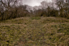
The Bledlow Cross is relatively easy to find, but despite being so close to a National Trail it isn't signposted in any way.
 I'd been here before, some time in the 1970s. Friends of Mum and Dad's owned Warren Cottage at Wainhill, so we'd stay there from time to time and collect firewood from the woods. Dad was excited on the day we found the clearing with the chalk cross. I remember being distinctly non-plussed, not immediately understanding what it was.
That was thirty years ago. Today we returned to rediscover it.
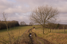
The easiest approach to describe is from Hempton Wainhill. The bridleway running south from the hamlet soon turns south-west, and as the last garden fence comes to an end on the left (east) a feint path climbs the ridge between the trees. Follow the crest of the ridge, and as it reaches its summit look out for the clearing ahead and to the right. The cross itself is at SP769009 and a height of 211m.
I don't remember what the cross looked like previously, but now it's heavily overgrown. English Heritage have it on their list of monuments at risk. It's easy to imagine the cross disappearing altogether, perhaps only to be rediscovered by energetic sons and fathers out for a walk together.
Dad died ten years ago today. Revisiting a moment in the Chilterns seemed the best way to commemorate that.