Thursday, 24 May 2018
Pennine Way
Windy Gyle → Kirk Yetholm
 Distance: 15.12 miles
Ascent: 761 metres
Duration: 5 hours 21 minutes
Journey's end
« Not walked | Not walked »
 We said a sad goodbye to our temporary companions this morning and headed off in the minibus to begin our final walk of the Pennine Way. The bus route took us along the military road, in places still wreathed in the overnight mist, back to Trows farm, where we started the long climb back up to Windy Gyle. Low cloud shrouded the valleys to the north, a fitting symmetry to our first walk on The Way when we left Edale in September.
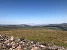
The lumpen mass of The Cheviot is on a spur off the main route of the Pennine Way, but it seemed churlish to not reach its summit. You don't do this for the views: the hill's upper reaches form a gentle dome that obscures the vista in all directions. Back on the main ridge there's plenty to be seen, especially the spectacular gully of Hen Hole.
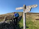
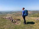
Before we knew it we were crossing the border for the last time, although the path still had a few tricks up its sleeve. Lazy map-reading meant that I'd assumed today's walk was "up to The Cheviot, then a long descent to the end". That's not what we got; the high-level route continues a switchback across summits and bealachs - going up and over White Hill is particularly cruel - before finally reaching the road just outside Kirk Yetholm.
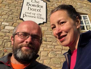
From the road we reached the village very quickly, and in the village: the Border Hotel. There's a book kept behind the bar for Pennine Way walkers to record their completion, and a reward of a free half pint of beer and a certificate. While we drank we noted with pleasure our friends' signatures and comments with just a hint of sadness that we'll not meet up again.