Friday, 18 May 2018
Pennine Way
Dufton → Alston
 Distance: 20.04 miles
Ascent: 1056 metres
Duration: 7 hours 26 minutes
Settling an old score
« Not walked | Not walked »
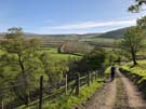
A combination of good weather, leave allowance and determination means that seven months after we reluctantly called time on our previous effort, we're back on the Pennine Way. And what a way to start: the longest and potentially toughest section of the Way.
 Both of our guidebooks describe today's section over Cross Fell with foreboding, highlighting its potential difficulties with harsh weather, tricky navigation and energy-sapping climbs. Thankfully, after a cold night today began with clear blue skies and light winds, and as we made our way out of Dufton the tops of the fells were clear and cloudless. It was a good omen.
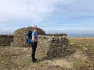
The route climbs steadily, over Knock Fell with its square cairn, on to Great Dun Fell with the curious golfball radar station. We had the route to ourselves, with just the rabbits, curlews and lapwings for company.
Cross Fell, the looming plateau, had been in sight for most of the morning but ascending to it was mostly straightforward (follow the numerous cairns). We're aware that we caught it on one of its rare peaceful days, but standing in the sun by the cross-shaped summit shelter it seemed that the fell's earlier name, Fiends Fell, was rather undeserved. The views from the summit were glorious, not least due to the absence of roads and buildings. This is a truly wild place.
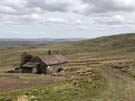 There's opportunities to go really wrong on descending from Cross Fell; even in clear daylight, we veered into wet ground, but once Greg's Hut came into view we were able to navigate towards it safely. We popped inside and felt extremely grateful to the Mountain Bothies Association for maintaining shelters like this; had we continued our walk in October it's highly likely that the availability of a place like Greg's Hut would literally have been life-saving.
The rest of the descent followed a hard, stony path over grouse moorland for several miles, heading to sheltered Garrigill in the valley, surrounded by fields of sheep with young lambs, basking in the sun.
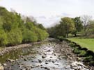 Almost the best part of the walk came last: the final few miles to Alston follow a lush, bucolic path along the River South Tyne, full of flowers and sweet meadow grass. It felt like a totally different walk, and a great way to end a day that redeemed our previous encounter with the Way.
One final note: if you're looking for somewhere to stay in Alston we highly recommend the Youth Hostel, if for no other reason than because you can enjoy watching red squirrels eating their dinner and breakfast outside while you enjoy yours.