Monday, 19 February 2018
Cotswold Way
Dowdeswell → Birdlip
 Distance: 10.96 miles
Ascent: 523 metres
Duration: 4 hours 19 minutes
Cheltenham and Gloucester
« Not walked | Not walked »
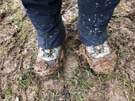 Heavy rain passed overnight, turning much of today's route into thick, claggy mud. It left behind a low cloud which muffled all views. Despite the mizzle we managed to see the Devil's Chimney, an interesting rock stack left behind by quarrymen on Leckhampton Hill.
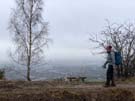 Later on we also caught a glimpse of Cheltenham, with GCHQ's "doughnut" offices just visible (though not mentioned on the toposcope). Another view claimed to show Gloucester Cathedral, but we couldn't make out a thing.
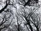 Mostly though, we've been walking in woodland, slowly making our way around the hills that fringe these two towns. On such a dreary day it's no surprise that the highlight was lunch. We can highly recommend the café at Crickley Hill nature reserve for jacket potatoes and cake.
Notes for future walkers:
- Once again our guidebook is out-of-date. South of the A40 the Cotswold Way now climbs almost as far as the A436 before turning west at SO 990 186, rather than passing through the centre of Lineover Wood.
- The A417 by the Air Balloon pub at SO 935 161 is the most dangerous road crossing we've ever had to make: traffic approaches the roundabout in two lanes at insane speed, and there's a blind corner to make it even trickier. Good luck.