Sunday, 6 August 2017
North Downs Way
Canterbury → Dover
 Distance: 20.48 miles
Ascent: 468 metres
Duration: 6 hours 47 minutes
The pilgrimage continues
« Not walked | Deal »
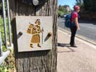 We were surprised to see that the path out of Canterbury was still called "Pilgrims' Way," and that it was accompanied by small waymarks of a yellow person carrying a bag. These indicate the route of the Via Francigena, a thousand kilometre route from Canterbury to Rome. If we didn't have any other walking projects on at the moment it would be tempting to follow along.
The route through the last twenty miles of Kent is relatively unremarkable. It's much of the same: wide open fields, chalk downland, oast houses, villages and parkland.
 Dover itself came as a bit of a shock. After all this countryside, being thrust into the town was a jarring experience, especially as the town is defended by a busy dual carriageway road to the port. The town seems to be generally bypassed by most people — it's not interesting enough to stop in, on the way in or out of the country, but it's significantly influenced by its proximity to mainland Europe. On the seafront only a Banksy mural begins to wonder what will change here in the next few years.
So that's it: the North Downs Way is complete. Whilst we're tempted to walk on to Rome, we're instead getting on the train home to plan our next National Trail.
Notes for future walkers:
- If your guidebook tells you that the Trail ends in the Market Square, it's wrong. Continue ahead through a subway to the seafront where a plaque embedded in the prom provides a much more fitting conclusion to the walk.