Sunday, 23 April 2017
Coastwalk
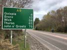
Dornoch → Golspie
 Distance: 18.12 miles
Ascent: 182 metres
Duration: 6 hours 1 minute
As a student in the early 1990s I shared a tiny flat on Sutherland Avenue in London. Back then I didn't know who road was named after, or about the vast region of Scotland that shares the road's name. Yesterday we entered the old county of Sutherland and will not complete its coastline until sometime in 2019.
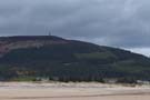 For much of today we've been crossing land owned by the Sutherland Estate, and for the entire walk we've been watched over by "The Mannie" — a statue of the first Duke of Sutherland that dominates the view for miles around. It was erected in 1834 on a hill above Golspie. One hundred and sixty years later persons unknown attempted to blow up the statue in order to destroy a reminder of this exploitative landowner.
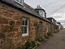 At the start of the 19th century the Duke and Duchess of Sutherland were responsible for some of the most egregious acts of what became known as the Highland Clearances. In order to turn their land over to large-scale sheep farming they decided to relocate communities of crofters to the coastal fringes and encourage them to take up fishing and arable farming. One of the destination communities was the part of Dornoch now known as Littletown, which became a kind of refugee camp in 1814. Here the Highlanders built homes and "improved" the land, but were ultimately still indebted to the Sutherland estate to whom they continued to pay rent, and whose land they improved. Contemporary records claimed that this was a futile effort, and indeed today it's hard to discern any evidence of arable land use.
One hundred years before the clearances the site of the settlement was the scene of another grizzly occurrence. The last person in the UK to be lawfully executed for witchcraft was burned at the stake here in 1727. I wonder whether the Sutherlands knew full well what they were up to, and in selecting the Littletown site were sending a not-too-subtle message to those they had evicted.
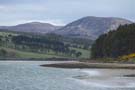 So on today's walk from Dornoch to Golspie, the Clearances were never far from my mind, particularly when looking up the verdant glens now clear of townships, cleared even of the sheep farms that replaced them and which now wait for the sporting pleasure of the wealthy.
Notes for future walkers:
- The Witch Stone is in the easternmost garden on Carnaig Street in Littletown (NH 801 893).
- In Embo, walk through the caravan park past the last row of houses, then turn left towards the sports ground. The track to the disused railway begins behind the pavilion / community shop (NH 816 930).
- We left the disused railway where the minor road from Fourpenny turns west (NH 803 947).
- Look out for seals on the sandbanks at NH 790 957.
- We followed the A9 from The Mound at the head of Loch Fleet to the road to Pinegrove Contact (NH 794 987). This was a bad move since the track from the cottage to Balblair Wood became difficult to follow at NH 794 981). We ended up retreating and following fields before re-entering the wood at NH 803 977. If we were to walk this leg again we'd either leave the A9 at Kirkton to access the wood at that same point, or try to find our way along the foreshore from The Mound.
- We couldn't find the track running south on the east side of the Culmaily Burn so walked the road to Littleferry instead.
- From Littleferry we found it easy to pick up paths and then the beach to Golspie.