Friday, 17 March 2017
Offa's Dyke Path
Mellington → Buttington
 Distance: 13.99 miles
Ascent: 514 metres
Duration: 4 hours 31 minutes
Beacon Ring
« Not walked | Not walked »
I'd identified the first half of today's walk on the final descent yesterday. The arrow-straight line of Offa's Dyke is easy to pick out as it makes its way across the broad Vale of Montgomery. It was reminiscent of some of my coastwalks in Lincolnshire: monotously following an embankment for mile after mile.
Relief came in the form of Long Mountain. The one climb of the day made its presence felt, rising to a commanding position above the Shropshire plains (though it's more a hill rather than the mountain its name suggests). The summit at one end — two miles east of Welshpool — is Beacon Ring, a large iron-age hill fort with a hidden message.
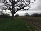
![]() The fort ticks the usual boxes: a round earthwork consisting of a towering embankment and deep ditch with two entrances, and some trees in the middle. What's unusual is that the trees are rather densely planted, and obscure a trig point in the very middle which surely couldn't have been used since planting.
The fort ticks the usual boxes: a round earthwork consisting of a towering embankment and deep ditch with two entrances, and some trees in the middle. What's unusual is that the trees are rather densely planted, and obscure a trig point in the very middle which surely couldn't have been used since planting.
The mystery is solved from the air. The trees are mainly beech, surrounding a small number of fir. They were planted in 1953, and at the right time of year the firs depict the monogram EIIR. The main question remaining for me is why commemorate the coronation in this way on top of a hill where so few people can see it? Had the same arrangement been made on the slopes the message would've been legible from the plains below, as is the case with the V of trees above Plumpton on the South Downs, commemorating Queen Victoria's Golden Jubilee.
From Beacon Ring it's downhill all the way to the end of the walk where the Path crosses the River Severn, last seen at Sedbury Cliff on day one.