Thursday, 30 June 2016
Glyndŵr's Way
Cemmaes Road → Llanddwyn
 Distance: 25.89 miles
Ascent: 1436 metres
Duration: 7 hours 51 minutes
Catch-up
« Not walked | Not walked »
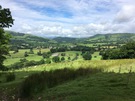
Yesterday's foreshortened walk meant that I'd lost the extra half day's walking I'd gained earlier in the week. The opportunity to reach Welshpool by the weekend was slipping away. As I lay in bed last night I hatched a plan: with one huge day today, I could be back on track.
I started early and walked fast. From the valley below, the rattling of the familiar train from Aberystwyth greeted all who were awake to hear it. There was no time to admire St Mary's Church in Llanbrynmair or the old chapel that my guide book raved about.
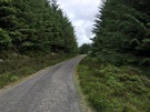 There was time however, to engage in a rare conversation. In the Dyfnant Forest I met Martin, the first Glyndŵr's Way walker I'd met since the campers on day two. His accent marked him out as from Central Europe, but I didn't ask where. He'd walked half the Way with his wife and children seventeen years ago and was now back to complete it although like me the torrents had hit his plans, leaving him to spend two days drying off in Llanbrynmair. I hope he felt welcome in the village. "I hope," I would have liked to say, "you will always feel welcome in our country." (Some of the rhetoric espoused on television these past few weeks would imply otherwise.)
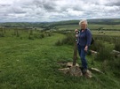 Mum had walked up to meet me at Eithin-llwyn, supplied me with fruit and then caught me again at Llangadfan although this time she directed me at the wonderful home baking on sale in the village shop.
 Suitably refueled I continued, and before too long saw in the distance the water of Llyn Efyrnwy. There's a photograph of Mum and Dad here on their honeymoon. It was December 1967. Foot and Mouth control had closed the countryside so instead of walking they drove to a different body of water each day.
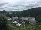
The lake was one of the first built by English municipalities to provide a reliable water supply. The flooding of valleys and eviction of communities in one country for the benefit of another ring echoes of the independence and EU debates. Llanddwyn village — now nestled beneath the dam — was reconstructed after being moved here from the valley just before flooding. There's little mention of this in the Vrynwy Experience exhibition.
Notes for future walkers:
- Rather than visit Llanbrynmair, the path now runs directly from Bryn-aire-uchaf (SH 898 040) to Clegyrddwr (SH 901 038), which it routes around on the north before joining the minor road from Pandy-rhiw-Saeson and heading into the fields once more at SH 901 032. While the start of this detour was well marked, I lost the trail between the two farms.
- The last bit of the path through the plantation at SH 941 066 was very wet underfoot, and the land across to the side of Eithin-llwyn (SH 946 063) was similarly boggy, as was the north-eastern side of Pen Coed (SH 996 092).