Monday, 10 February 2014
Coastwalk
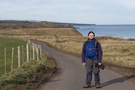
Holy Island Causeway → Berwick-upon-Tweed
 Distance: 10.32 miles
Ascent: 108 metres
Duration: 3 hours 26 minutes
The last map in England
« Bamburgh | The Border (Marshall Meadows) »
 Explorer Map 346 is the most northerly in England. Today it became the last map of the English coastline that we've not completed. We're nearly done!
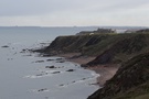
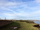
 Our original plans had us including a circuit of Holy Island in the coast walk, but tides and lack of out-of-season bus services caused us to rethink. Consequently we had a shorter walk than expected today, and it's been the best walk of the week so far.
 Two thirds of the way along the walk we passed within metres of the cottage where we've been staying, but decided that rather than stop we'd continue going until we'd crossed the River Tweed.
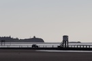
Berwick soon came into view, defended from the river by towering ramparts. It looked formidable from the southern side of the river, the town's history of switching back and forth between Scottish, English and independent affiliation ever so believable.
 Above our heads, two jet contrails crossed to form a perfect Saltire in the sky. It felt appropriate somehow.
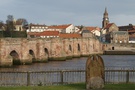 Crossing the river on the Old Bridge felt like a crossing a threshold. This was the border once upon a time after all.
We have a few days off now: we'll be joined by family on Saturday for the final walk although with the end in sight it's tempting to just get out again tomorrow before the weather turns for the worse again.