Friday, 16 March 2012
Coastwalk , South West Coast Path
Saunton → Barnstaple
 Distance: 12.0 miles
Ascent: 55 metres
Duration: 4 hours 6 minutes
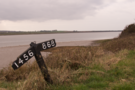
The estuary
« Mortehoe | Westward Ho! »
Today's walk — our final one in North Devon for now — was very different to the others we've done this week.
The high cliffs and deep combes of Exmoor were gone, replaced by expansive dune systems, river embankments, a disused railway and the long estuary of the River Taw.
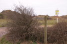 The first few miles were alongside the Braunton Burrows dune system. Much of this is an MOD training area, and our guide book warned that access may be restricted. I suspect that's a very rare occurrence: although it is clearly regularly used by the military, there was none of the usual paraphernalia of a firing range (for example, poles for red flags, sentry boxes and lockable gates).
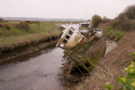
 Beyond Braunton village the path became a surfaced cycle track along the lines of a disused railway. For a couple of miles we followed the fence of RMB Chivenor, behind which a Search and Rescue team were preparing their Sea King helicopter.
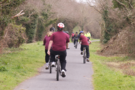 We were overtaken by a few dozen students next, cycling along perhaps on their P.E. lesson, some taking their cycling seriously while others sauntered past on low-seated choppers.
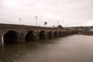 Finally the Long Bridge in Barnstaple came into view. We crossed, and stopped the walk near the railway station.
We've walked seventy miles this week, completing about half of the gap which we had between Minehead and Tintagel. Despite the fog it's been a very enjoyable time, but I can't help but wonder what the views would have been like were they not hiding.