Saturday, 31 March 2012
Capital Ring
Hanwell → Highgate
 Distance: 19.4 miles
Ascent: 357 metres
Duration: 5 hours 40 minutes
Northwest
« Not walked | Not walked »
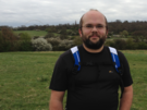
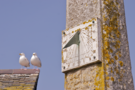
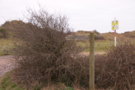
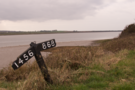
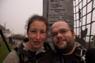
We have a habit of starting out on long-distance paths, then leaving them unfinished for months or even years on end. One day we'll complete the North Downs Way and the Thames Path, but for now it's back to a path we started around this time last year: London's Capital Ring. After today's rather lengthy outing we should be able to complete the circuit with just one more walk.
Two themes characterised this section: unexpected wildlife and diverse cultures.
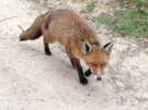 Close to our starting point we saw a green woodpecker rooting around in a field; later, we heard another quite clearly chipping away at a tree. A short distance we came across another unusual sight: right in front of us on the path on Horsenden Hill stood a fox. We hushed our voices, fully expecting it to run off, but instead it began to approach. When it wasn't scared off by a shout, or a stick tossed in its general direction we decided to take a different route.
These types of encounter are not what you'd expect from an urban walk, but as we've been learning, the Capital Ring is wilder than you would imagine for a walk that's never more than ten miles from the centre of London.
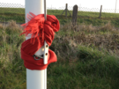
What you do expect from London is a diversity of cultures. Starting near Southall we were the odd ones out in a bustle of Asian faces. Then later at Brent Cross we passed under the fishing-wire boundary of the Northwest London Eruv, where kippah-wearing boys scurried along the pavement.
The notion of the eruv - a large public area designated as a "private place" for the purposes of Jewish law, so as to facilitate observance of the sabbath - has fascinated me since the Northwest London Eruv was originally proposed. In practise the eruv was only visible because I knew where to look out for the fishing wire strung between lamp posts as we entered, and the increase in obviously Jewish dress. The streets felt quieter on this Saturday, but that was probably in my imagination rather than in fact. I didn't notice where the exit was.
So although I find the notion of an eruv rather curious - it seems to me little more than an elegant religious hack - I saw nothing to justify the fear that was being spread at the time this was originally constructed.
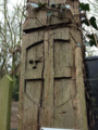 The final section of the walk was in woodland, a delight to be in the shade after a long day in the sun. London does urban woodland very well, and I imagine that had I found myself living in north London as a student I would have spent many days exploring Highgate Wood. We celebrated the end of the day with ice cream eaten from comedy teddy bear-shaped cones.
Sunday, 25 March 2012
Coastwalk , South West Coast Path
Portwrinkle → Plymouth
 Distance: 13.8 miles
Ascent: 628 metres
Duration: 5 hours 1 minute
Sport Relief
« East Looe | Wembury »
Before we get to the walk, we must mention the pub. The Finnygook Inn offers excellent local food and ales, a friendly welcome and a very comfy bed. We needed to let ourselves out early this morning, before the breakfast service started, but the staff very kindly left us some croissants and cereal in a fridge by the stairs so we wouldn't go hungry.
 The MOD occupy a large tract of land at Tregantle Fort, and although we knew the range would see live firing later in the day, the warning flags had not been raised when we reached the permissive path across the estate - clearly the notion of an early start doesn't apply to everyone!
The range walk has steadily been extended here in recent years (our guide book made no mention of it , once again recommending road walking instead), so by the time we left the range we were already at the National Trust land at Tregantle Cliff, staying off the road one more.
With Rame Head drawing us forwards we passed through the higgledy-piggledy chalets at Freathy. Only looking back on this section from the path above Penhowan Fort did we see just how these huts encroach on the otherwise beautiful gorse and bramble covered hillside.
 The chapel on top of Rame Head was a disappointment. Open to the elements, there are no visible signs of sanctity here, but it was worth the climb for the hazy views and offered a sense of peace despite being open to the elements and howling wind. Below a small herd of deer lay contentedly on the hillside.
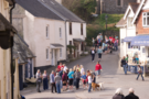
The walking got easier at this point, and before long we found ourselves amidst dozens of others heading along the coast path to complete their Sport Relief Mile. We were consequently part recipients of a misdirected round of applause as we entered Cawsand Square, so marched on to avoid embarrassment all round.
 The division between Cawsand and Kingsand isn't clear, but the old county boundary between Devon and Cornwall is definitively marked in wrought iron on the wall of a house here.
 The route out of Kingsand is another poorly marked point, but if you look for the narrowest, most winding, improbable lane you'll likely find Heavitree Road. These narrow lanes reminded us of Angel Lane in Woodbridge. It's safe to assume we'll return.
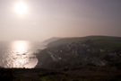
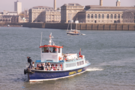 Mount Edgcombe Country Park was the backdrop for the final three miles, a beautiful extensive public park just across the water from Plymouth. So at its eastern end we queued for the Cremyll Ferry, paid our £1.20 fares and joined families enjoying a day out as we crossed the Tamar to Admiral's Hard in Stonehouse, from where we had walked to the east three years ago.
Saturday, 24 March 2012
Coastwalk , South West Coast Path
East Looe → Portwrinkle
 Distance: 8.26 miles
Ascent: 649 metres
Duration: 3 hours 28 minutes
Undulating
« Polperro | Plymouth »
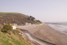
Here's a surprise: we're in Cornwall. It seems a bit of a long way to go for the weekend, but the gorgeous weather, fresh breeze and stunning cliff top walks are well worth it.
The goal of this weekend is to complete our remaining gap in the Cornwall South Coast Path. All being well, tomorrow we'll cross the Tamar into Plymouth.
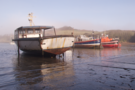
 Starting at Looe lifeboat station we didn't take the signed coast path, which rises by road from the town centre, but instead took the zig zag path up behind the cafe on East Looe beach.
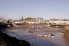
Looe is under construction. Or rather, the modern holiday home part of the town is. It seemed as if every other plot of land was half built, with luxury villas - far beyond the financial reach of the locals - rising from the ground. Somehow, all of this building seemed wrong.
 Notices posted along the sea wall at Seaton do their best to discourage walkers from taking the beach route, instead offering the road through Downderry as an alternative. We took the beach, and would recommend it although at high tide it may be impassable.
The remainder of the day was along undulating cliff paths, through woodland and along field boundaries. Take note of the word "undulating": there was significantly more ascent and descent here than was readily discernible from the map.
The Gook cafe at Portwrinkle provided a welcome cup of tea after this tiring afternoon's walk. It also provided a moment of excitement as we noticed in the adjacent car park a litter bin which appeared to be on fire. Someone had discarded a smouldering barbeque, which in turn was heating up the contents of the bin. I doused it with what remained of my day's water.
 We stopped just east of the village, at the top of the next climb. Here a path runs inland to a point on the road between Portwrinkle and Crafthole, where we're spending the night. This should spare us a steep ascent first thing tomorrow morning.
Friday, 16 March 2012
Coastwalk , South West Coast Path
Saunton → Barnstaple
 Distance: 12.0 miles
Ascent: 55 metres
Duration: 4 hours 6 minutes
The estuary
« Mortehoe | Westward Ho! »
Today's walk — our final one in North Devon for now — was very different to the others we've done this week.
The high cliffs and deep combes of Exmoor were gone, replaced by expansive dune systems, river embankments, a disused railway and the long estuary of the River Taw.
 The first few miles were alongside the Braunton Burrows dune system. Much of this is an MOD training area, and our guide book warned that access may be restricted. I suspect that's a very rare occurrence: although it is clearly regularly used by the military, there was none of the usual paraphernalia of a firing range (for example, poles for red flags, sentry boxes and lockable gates).
 Beyond Braunton village the path became a surfaced cycle track along the lines of a disused railway. For a couple of miles we followed the fence of RMB Chivenor, behind which a Search and Rescue team were preparing their Sea King helicopter.
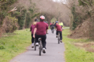 We were overtaken by a few dozen students next, cycling along perhaps on their P.E. lesson, some taking their cycling seriously while others sauntered past on low-seated choppers.
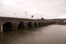 Finally the Long Bridge in Barnstaple came into view. We crossed, and stopped the walk near the railway station.
We've walked seventy miles this week, completing about half of the gap which we had between Minehead and Tintagel. Despite the fog it's been a very enjoyable time, but I can't help but wonder what the views would have been like were they not hiding.
Thursday, 15 March 2012
Coastwalk , South West Coast Path
Lynton → Combe Martin
 Distance: 12.8 miles
Ascent: 775 metres
Duration: 5 hours 23 minutes
On the roof
« Porlock Weir | Mortehoe »
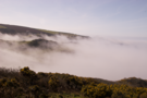
Have a guess at the state of the weather. Yup: fog. It seems yesterday was the only clear day we'll get. We couldn't put off the one remaining Exmoor walk any longer, so despite once again being unable to enjoy the views we were up on the roof of the South West Coast Path.
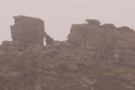 First up today was the one part of the North Devon coast I'd been to before: The Valley of Rocks, and beyond it Lee Abbey. We only saw a couple of the Valley's herd of feral goats on our way through but when we looked back we saw perhaps twenty or thirty congregated in a car park (morning assembly, perhaps?).
 As we dropped down to Woody Bay we caught up with the first of three groups of DofEers that we saw during the day. There's nothing like a handful of testosterone-filled eighteen year-olds to hurry you along. Unfortunately, being overtaken by a middle-aged couple isn't their idea of fun either so for a while we leapfrogged each other on the path through the woods.
 We knew there would be two significant descents and ascents on this section, the first at Heddon's Mouth Cleave and the second at Sherrycombe. It seems the first put off all other walkers. Up until that point we had frequently passed others, but beyond we were the only people on the path. There was a significant amount of climbing elsewhere too, but these were the most prolonged sections. The steep, slippery descent into Sherrycombe at times felt more arduous than the following ascent.
Next came Holdstone Down and the unexpected highlight of the walk. About fifty metres away we saw six deer in two groups catch sight of us and disappear into the mist.
Finally we reached the very apex of the roof of the path: towards the end of the walk we summited Great Hangman, which at 318m above sea level is the highest point on the entire 630 mile National Trail. I think the only place that beats it on the coast walk so far is Bwlch yr Eifl on Llŷn. If only we'd been able to see beyond the end of our noses.
Wednesday, 14 March 2012
Coastwalk , South West Coast Path
Mortehoe → Saunton
 Distance: 9.56 miles
Ascent: 173 metres
Duration: 3 hours 42 minutes
Bright and early
« Combe Martin | Barnstaple »
Fog report: it appears to be lifting, with visibility now measured in miles. However, since it's not entirely gone we decided this morning to do a low-level walk rather than the remaining high-level one from which we hope to be able to see across to South Wales.
 Walking from the cottage meant we could start early. As we passed through Woolacombe, it was clear the surfers weren't following a similar strategy: the waves on the two mile long beach broke with nobody riding their backs, and half a dozen vans were parked and shuttered up in lay-bys.
(Incidentally, a sign in one lay-by forbade camping, cooking and "personnel ablutions". The locals must wash their staff elsewhere.)
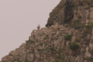 After the beach, the headland. Baggy Point guards the southern end of Woolacombe Bay, and was a popular place for a stroll today. As we reached its extremity, an excited birdwatching couple pointed out a peregrine falcon perched on its cliff top lookout. (Sadly we'd not taken a long lens with us so the photograph isn't exactly spectacular.)
 Although it was still early by the time we reached Saunton, neither of us was in the mood to walk any further so we abandoned the walk and took a bus back to the cottage.
Waiting for the bus, we got chatting about walking with a couple of locals. "You know, some people who come by here are trying to do the whole coast," the man said, rolling his eyes at the stupidity of such an endeavour. We kept quiet at that point.
Tuesday, 13 March 2012
Coastwalk , South West Coast Path
Porlock Weir → Lynton
 Distance: 12.6 miles
Ascent: 703 metres
Duration: 5 hours 13 minutes
Into the woods
« Minehead | Combe Martin »
It's foggy again. In fact, at one point today our visibility was down to twenty metres. I nearly pulled the compass out to assist navigation, but at that moment a gentle breeze parted the mist and showed us the tower of Countisbury church. With such poor visibility and the path criss-crossed by sheep tracks and other footpaths, it would have been easy to get lost.
 After climbing out of Porlock Weir and passing the toll house of the Worthy Toll Road, we entered woodland carpeted with new spring growth. We saw deer tracks beneath our feet, heard owls hooting above our heads and watched squirrels chasing each other through the trees. The bulk of the day's walking was woodland like this.
 One highlight was Culbone Church, a small, ancient stone building dedicated to Beuno, a popular Welsh saint. It was close to this church, at Ash Farm, that Samuel Taylor Coleridge wrote the opening passages of Kubla Khan whilst recuperating from an illness — a work that was allegedly fatefully interrupted when the original "person from Porlock" knocked at the door and disturbed Coleridge's train of thought.
The path continued through the woods, crossed the border into Devon and took us past a track to the intriguingly named Desolate Farm. Finally it climbed The Foreland and began the long descent into Lynmouth.
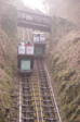 Although we'd parked in the town we pressed on with one last climb: up the steep hill to Lynmouth's sister, Lynton. We were keen to do this now, despite our tiredness since it would have made a rather frustrating start to the next walk otherwise. Besides, we could relax on the way back down by taking the cliff railway and enjoying what we little could be seen of the view out to sea.
Monday, 12 March 2012
Coastwalk , South West Coast Path
Minehead → Porlock Weir
 Distance: 9.52 miles
Ascent: 254 metres
Duration: 3 hours 46 minutes
Start at the beginning
« West Quantoxhead | Lynton »
Here goes then, what is for most people their first day on the South West Coast Path is in fact our forty-fifth. It's about time we tackled the "start" of the National Trail.
A sculpture of hands gripping a map thrusts out of the promenade at Minehead, marking the official start point of what is presently Britain's longest National Trail. On the floor to the west of the monument is an arrow showing the direction of the walk. Rather pleasingly for me, there's an arrow on the east side too, pointing out the West Somerset Coast Path extending in the opposite direction. The notion of a continuous path all the way round our island appears to be gaining traction. If all goes to plan we'll be back here later in the year, having completed the Somerset leg.
Our maps showed the coast path heading through a narrow wynd and up the cliff right away. However, today we followed a more recent route, along the prom and up through the woods.
We didn't need to go very far before realising that the fog would be our companion once again. Once on top of the hill (the sole climb of the day), there was no escaping it. A "rugged, scenic, alternative path" is available but there seemed little point in us taking it today.
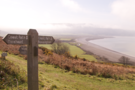 As we descended Bossington Hill the weather cleared a little and a view of the final part of the day's walk opened up: three miles along field boundaries on the fringe of Porlock Marsh.
Halfway across the marsh we found a monument commemorating the lives of a USAF crew whose plane had clipped Bossington Hill in 1942. On a day like today it's easy to see how such a mistake could have been made.
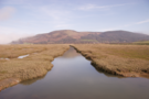 The monument also represents change. When originally erected it was located on the shingle bank at the back of the beach, but a decade or so ago a storm breached this ancient marsh wall, and since then the land management policy of the whole area has been one of managed retreat, with the sea water flooding in on each tide to create a new salt marsh. It's likely this path is impassable near high tide.
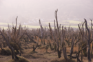 In front of the monument a strand of skeletal trees poke forlornly out of the ground, life drained out of them by the salt water.
Today's fog added understanding and atmosphere.
Sunday, 11 March 2012
Coastwalk , South West Coast Path
Combe Martin → Mortehoe
 Distance: 13.1 miles
Ascent: 894 metres
Duration: 5 hours 38 minutes
 The Plan calls for 2012 to be the year of the South West Coast Path, and three months in it's time we started ticking off the missing bits.
We had hoped to walk yesterday, but reality intervened so we spent the day driving instead. And with a limited (i.e. non-existent) bus service operating today, the sensible move seemed to be to take a taxi to a point from which we could walk back to the cottage we're renting for the week.
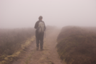
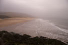
 Throughout the day the view was largely the same: dense fog. At times the next fingerpost sign was lost in the mist, and it was rarely possible to see beyond the nearest headland. Consequently the tail end of the walk seemed never-ending, with Morte Point only appearing at the final moment. We continued round to the southern side of the Point, conveniently just a quarter of a mile from our sea-view cottage.
 The town of Ilfracombe — approximately halfway through the walk — would have been a good place to cut the walk short had the need arisen. Just in front of the curiously-shaped Landmark Theatre, local boy (and long jumper) Jonathan Edwards' Olympic record-setting triple-jump is commemorated with a series of bronze and mosaic plaques set into the paving.
One great aspect of this section is that the coast path is never far from a road, so despite today's low visibility there was never any real risk of getting lost, and safety was always just a field boundary away.