Saturday, 14 January 2012
Coastwalk
Newport → Severn Tunnel Junction
 Distance: 16.1 miles
Ascent: 58 metres
Duration: 4 hours 45 minutes
The Gwent Levels
« Cardiff | Severn Beach »
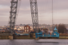
My first coast walk of 2012 started with a flight. I've long put off doing this walk, hoping that I could arrange to do it on a day when the high-level walkway of the Transporter Bridge is open to the public. Plans for this year are to do so on 3 June and 31 August - both after the official opening of the Wales Coast Path, which is my self-imposed deadline for finishing the country.
With that in mind, I decided to cross the river in the bridge's gondola, which is suspended just above the surface of the River Usk, hanging from a sled that runs on rails below the walkway.
The ride was amazingly smooth. I barely noticed the motion start, although admittedly there was a clunk when we reached the far side.
Newport doesn't know what to do with this bridge. "We've never turned a profit," the attendant told me. "Haven't had a car yet today." (This much was evident from the untouched frost on the wooden deck). "But we've recently been taken over by a different part of the council - one the looks after tourism - and the boss there wants to open the walkway year round."
This seems to be the key. Cars have to pay to cross, so typically use the free bridge just upstream instead. Pedestrians are free. It's amazing to think the bridge generates any income at all. But if I'd been able to use the walkway this morning I'd have gladly paid £5 to do so.
Newport is very proud of the bridge. And so it should be; she's a graceful centenarian, one of just two in the UK, and the longest of the dozen or so remaining worldwide. Here's hoping they come to realise its potential and keep it going another hundred years.
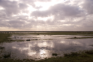
 Back to the walking! A new permissive path took me through grazing on the east side of the Usk, avoiding a few miles of country lane. A power station stands guard at the river mouth; in its shadow, the Newport Wetlands National Nature Reserve.
On the far side of the reserve, polite signs directed me inland away from the sea wall and I picked up peaceful paths fringing the salt marsh.
 I didn't walk all the way down to the sea wall at Goldcliff, but suspect that would've been a good option. There's no right of way marked on my map west of the road, but I could see people walking that stretch, and when the footpath that had taken me across further pastures (complete with newborn lambs already!) joined the sea bank there was nothing to deter those keen to head towards Goldcliff.
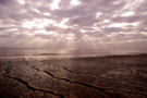 The remainder of the walk was on the sea bank. A cold wind picked up and sent the sun scurrying behind the clouds. It was a long, lonely walk to Rogiet Moor although the view across the Severn and ahead to the bridges never got tiring. England is very close now.
At Rogiet the military firing range was active, blocking further progress on the sea wall. I'd intended to stop here anyway to walk inland to the railway station at Severn Tunnel Junction. As it turned out, the path around the range goes almost as far as the station itself so it will be from here that I pick up the next - and possibly final - stretch in Wales.