Wednesday, 28 September 2011
Coastwalk
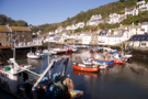
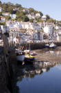
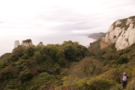
Polperro → East Looe
 Distance: 5.64 miles
Ascent: 236 metres
Duration: 2 hours 23 minutes
Two fishing villages
« Polruan | Portwrinkle »
And so to finish our walking this week with a piece of coast that neither of us knows.
Polperro and Looe are both fishing settlements, but there's no question in my mind that Polperro is the superior of the two. Looe may be more accessible, larger and more "happening", but the gentle confidence of Polperro won me over. Even though we were only there for a few minutes, the sense of community was inescapable, yet in Looe it was missing altogether (replaced by a tacky tourist-hungry feeling).
The path between Polperro and Looe was more popular than any other path we've been on this week. Dozens of folk were out exploring the coastline, the cream tea shops doing a roaring trade. (I can second my boss's recommendation of the Talland Bay Café.)
In the last field before Hannafore on the outskirts of Looe, we noticed a sign pointing towards a Celtic chapel some way up the hill. All that remains of Lamanna Chapel is the outline of the walls, but it makes an excellent picnic spot and its commanding view across to Looe Island, and the sweep of Whitesand Bay beyond was delightful and comforting.
It's been another hot day, so we were glad to not rush or try to go further. We'll be back to complete the walk into Plymouth sometime next year instead.
Tuesday, 27 September 2011
Rewalk
Torquay → Shaldon
 Distance: 12.0 miles
Ascent: 862 metres
Duration: 4 hours 36 minutes
Caught Up
« Brixham | Teignmouth »
Today's walk was only the second time that I've ever done a 'proper' walk on my own, which is strange to think given how much walking I've done over the last six or seven years. I started the day with a mixture of slight nervousness and determination. Pab's tiny, pencilled notes in the official trail guide, written after he'd done the walk for the first time in 2001, contained words like 'very strenuous' and 'erosion', so I was expecting the day to be both tiring and difficult. In the event, it wasn't nearly as bad. In fact, it was even good.
Once I'd left Torquay's seafront behind I was able to appreciate that this is actually quite a quiet stretch of the coast path. I'd arranged to meet Pab at intervals during the walk, but by our first meeting at Meadfoot Beach, looking out to Thatcher Rock, I'd barely seen anyone else. There were moments when this was a slight worry - I have to admit to a slight paranoia about personal safety - but I enjoyed being able to walk at my own pace, to stop to look at the different trees in the woodland on Black Head, and generally occupy myself with my own thoughts. By the time we met again at Oddicombe Beach (the steep slope down to the beach cafe almost finished my knees off) I was thoroughly enjoying the mental self-sufficiency of doing my own pacing and route finding.
Things nearly went awry around Petit Tor, the first serious deviation of the route from both the guide book and the map. Coastal erosion has caused the Coast Path to be re-routed around residential streets; the signage was slightly confusing in places, and I got briefly lost in a deep, grassy dip at St Marychurch. Once beyond this, the waymarking improved although the path itself did become quite twisted and narrow through the wooded Valley of Rocks.
Being alone gave me a different perspective on this section of the walk; in the quiet of the woods I became aware of myself as an intrusion. Leaves piled up around my boots as I picked my way over slippery, stony tracks, and there was a strong, fungal and damp smell of autumn. I took a moment to stand in a clearing to listen to a robin singing in a bush; above me, a jay landed in an oak tree.
My final catch-up with Pab, at Maidencombe, was my last chance to potentially cut the day short. It was tempting; Pab's notes (and recollection of the route) were clear that the hardest part - described in the guidebook as 'tiring' - was yet to come. But I was determined to finish the walk. It wasn't too difficult until just before the end, where the long, steep slog up a field really started to hurt. It was only when I dropped down the other side of the hill that I realised I was almost at the end of the walk, so I was genuinely excited at the prospect of finishing. Pab met me by the road into Shaldon with a Devon takeaway: scone, clotted cream and a tiny pot of jam packed carefully in a paper bag.
Originally walked on 20 February 2001.
Monday, 26 September 2011
Rewalk
Sidmouth → Seaton
 Distance: 10.1 miles
Ascent: 642 metres
Duration: 4 hours 16 minutes
The End of the Book
« Budleigh Salterton | Lyme Regis »
Here's a small landmark: after this walk, Emma had completed one book in the four volume series of guides to the South West Coast Path. Cause for a small celebration. Small because tomorrow's landmark will be greater: she will have caught up with me on the trail.
The path from Seaton to Sidmouth is an absolute delight. It starts with three steep ascents: out of the town, and then across two deep valleys. After a plateau and a hill fort, it descends to Branscombe Mouth on an ancient wooded track.
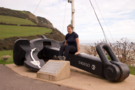
It was here that cargo from the abandoned MSC Napoli was washed ashore in early 2007. The ship's misfortune may not had been an intended wrecking, but the frenzied treasure-hunting that ensued on the beach showed the pirate spirit is still alive on our shores. The ship's fourteen tonne anchor stands at the head of the beach as a monument to this moment of madness.
Between Branscombe and Beer Head there are two path options, but by far the most interesting is the lower path which meanders through the Hooken Undercliff, twisting, turning, ducking and diving more than any roller coaster. Although not as extensive as the under cliff between Seaton and Lyme, the Hooken is to my mind more impressive as it is less overgrown and grants clearer views of the towering, then slumping chalk cliffs.
Originally walked on 22 April 2002.
Sunday, 25 September 2011
Rewalk
Budleigh Salterton → Sidmouth
 Distance: 6.81 miles
Ascent: 295 metres
Duration: 2 hours 25 minutes
High Peak and Peak Hill
« Exmouth | Seaton »
I remember being surprised (and glad) to be alive after the first time I walked this section of the coast. It was a baking hot day, and the climb up to High Peak north of Ladram Bay seemed as if it would finish me off. Today that hill wasn't so bad, but since my memories of this section were so wrapped up in that one climb, I'd failed to notice that it was shortly followed by another: Peak Hill. This is getting to be a habit: remembering the first hill, but forgetting all others.
Originally walked on 21 April 2002.
Saturday, 24 September 2011
Rewalk
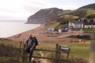
Lyme Regis → West Bay
 Distance: 10.1 miles
Ascent: 770 metres
Duration: 3 hours 57 minutes
Over Golden Cap
« Seaton | Abbotsbury »
Two days ago our plans for the coming week were set in stone: we'd take four days to fill in the remaining gaps I had in the southern coast of Devon and Cornwall. That crumbled when I consulted tide, bus and ferry timetables. Instead we're walking the sections of the south-west coast path that I walked before I met Emma. With any luck, by mid-week she'll have caught up and we can head down to our favourite hotel for some cream teas.
First up: Golden Cap, the highest point on the south coast of England.
Ten years ago when I walked this before, there were diversions due to cliff falls either side of the village of Charmouth. My hopes that these had been lifted and the original path line reinstated were dashed; as before we had to climb almost as far as the A35 and then follow the road through the back of the village.
Golden Cap is one of those few geographic features that actually deserves its name: it sandy summit is instantly recognisable for miles around. Although it's the highest point on the south coast, the climb is neither as steep, or the sense of height as dramatic, as some of the other Jurassic Coast landmarks such as Flower's Barrow on the Lulworth Estate.
What I'd forgotten were the subsequent climbs. After descending into Seatown we still had Doghouse Hill, Thorncombe Beacon and West Cliff to conquer before returning to the car at West Bay. Keeping us company on this section were a handful of paragliders sailing though the sky above our heads.
Atop Thorncombe Beacon a passing walker offered to take our photograph. "I can't see anything on the screen, so I'll have to guess whether you're in or not," she said. She'd not noticed the viewfinder. The path may not have changed in ten years, but we certainly have.
Originally walked on 23 April 2002.
Friday, 9 September 2011
Tech
Not inspiring confidence
Making a first impression always counts. It's a good job our first impression of the local pizza delivery company wasn't their website. The menu is stuffed full of inconsistent capitalisation and blindingly obvious spelling mistakes such as pinepple, pinapple, pepronni, tamatoes, Hawaian, meetballs, chicken strpipers and potoato.
 But our favourite feature of the website is the "cooking notes" that you can add to any item ordered. Extra bacon on that chocolate cake? Yes please.
I don't know about you, but that lack of attention to basic detail doesn't fill me with confidence, and I certainly wasn't keen on letting them have my card details.
Still, their pizza tastes good; we phoned our order in and paid cash.
Monday, 5 September 2011
Coastwalk
Llanfairfechan → Bangor
 Distance: 8.91 miles
Ascent: 263 metres
Duration: 2 hours 30 minutes
Unfinished Business
« Conwy Morfa | Beaumaris »
Fourteen hours out of the house for just two and a half hours of walking doesn't seem particularly sensible, but I had unfinished business in Gwynedd and didn't want this walk hanging over me any longer.
Unfortunately it appears Gwynedd had unfinished business with me too. Just two weeks ago Emma and I curtailed our intended walk to Bangor due to the sight of an impending downpour. That cloud seems to have been biding its time: ten minutes after I'd started to walk, the cloud sailed up the Menai Strait before crashing directly into me.
I could still hear the farewell of the train conductor when I disembarked: "At least you'll only get wet once", or the consolation prize offered by a dog walker who saw me hurriedly putting the camera away: "You might get lucky and see a rainbow". (I didn't.)
Once I'd dried out, the first five miles formed a lovely walk between the farmland and the shore. Particularly delightful was the footbridge across the Afon Aber which flowed fast through a gorgeous glad of trees.
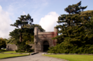
The final three miles were less interesting as I was diverted inland by my usual nemesis: private land. The National Trust may manage Penrhyn Castle, but they seem keen to keep walkers off the estate, resulting in a rather anticlimactic descent into Bangor on the roads.
But my goal is achieved: I've joined up the last parts of the North Wales coastline. Only a couple of walks left in South Wales now and I'll have finished my first country.
Note to future walkers: stay outside of the nature reserve at Glan-y-Mór Elias since there is no exit from the western side of the reserve.