Wednesday, 2 March 2011
Coastwalk , Isle of Anglesey Coastal Path
Cemaes → Llanfaethlu
 Distance: 11.8 miles
Ascent: 370 metres
Duration: 4 hours 33 minutes
The community shop
« Amlwch Port | Holyhead »
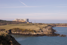
It would be impossible to write up this section without mentioning Wylfa nuclear power station. Its presence just a mile outside Cemaes dominated the early part of the walk, and although decommissioning is due to start here in a year or so, we could see surveyors busy preparing for a potential second power station.
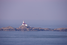
The next significant landmarks — in view since yesterday — were the Skerries, a chain of rocks a mile or two off Carmel Head, the north-west tip of the island.
Beyond Carmel Head the landscape changed dramatically. The low, rolling cliffs of the north coast gave way to steeper, rockier headlands and inlets which slowed our progress considerably. These lasted for about two miles, and by the time we reached Church Bay their ferocity was significantly diminished.
We finished the coastal section of the walk at Porth Trwyn but the remote nature of this coast means that the nearest bus stop is a mile inland at Llanfaethlu. This is a charming village with a fantastically integrated community shop, combining café, shop, post office, hair-dresser's and village hall in a single building called the Griffith-Reade Coffee House. That said, coffee will only be back on the menu when the kitchen refit is complete.