Tuesday, 7 July 2009
Fort William and Glen Coe , Munros
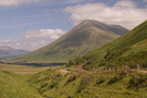
Beinn Dòrain
And so to the big question: after last year's success with Ben Nevis would we be tackling other Munros? The answer appears to be "yes".
 Distance: 6.71 miles
Ascent: 923 metres
Duration: 4 hours 13 minutes
Walk 23 / M064: Beinn Dòrain
It was too close to call as we drove across Ranoch Moor whether or not we'd make it to the top. Almost all summits were shrouded in cloud and we didn't fancy spending a day walking in drizzle.
Nevertheless once we arrived at Bridge of Orchy we decided to continue.
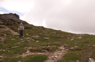 On reaching the col to the north of the summit the cloud had cleared sufficiently for us to march on. At this point we should have consulted our route more carefully. Instead of following the easy wide path along the spine of the hill, we missed one vital junction and found ourselves on a narrow route on the hill's western edge. The views were absolutely stunning, with the terrain to our right dropping away steeply nine hundred metres to the valley floor below. I knew we'd gone wrong, but scrambling up to the ridge looked more risky than continuing on the ledge. Eventually the path looped round the southern end of the hill and made its way directly to the summit at which point we were relieved to see the easy route down.
 While the view from the top was once again spectacular, a little part of me preferred the view from that narrow track a few metres below. I'd advise anyone else to take the ridge route if they are walking this hill for the first time, but if you like adventure stay on the edge.
One final tip. If you don't want to be renamed "Boggy Bogfoot", keep high just below the corrie. I didn't - but at least only one leg had to endure the squelching, and we were on our way down.