Saturday, 31 May 2008
Faith
A picture of community
I think everyone on the island this week has decided they want to live in a small western island community. Not as a tourist, and certainly not necessary on this Holy Island, but somewhere out here between the Atlantic and the mainland.
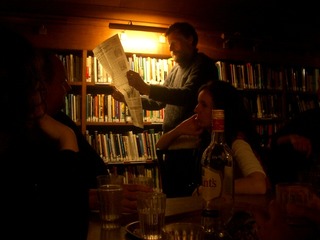
Time to get back to living with the tribe?
Tuesday, 27 May 2008
Faith , Walks
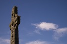
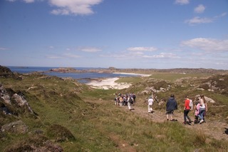
Iona Pilgrimage
Here's a walk I've done a few times before: the Iona Community's pilgrimage round the island of Iona.
 Distance: 6.9 miles
Ascent: unknown
Duration: 6 hours 17 minutes
What made today's Pilgrimage different to all the others was Alastair McIntosh, once business adviser to the Iona Community. At each stop after we'd heard from a current member of the Resident Group, Alastair would breathe fresh life into the surroundings. From fairy hills ("the only difference between fairies and angels is altitude") to the Nunnery's Sheela Na Gig; from encouraging us to walk bare-footed across the Machair to waking the rocks in the marble quarry with his thundering cry, this was a walk like no other.
Thursday, 22 May 2008
Coastwalk
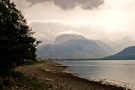
Corpach → Fort William
Distance: 3.83 miles
Ascent: 5 metres
Duration: 1 hour 29 minutes
In the shadow of the Ben
« Not walked | Not walked »
This week has been all about Ben Nevis so it should be no surprise that May's coastwalk is in the shadow of the Ben. It's the first coastwalk I've done in Scotland so serves as my public answer to a common question: when I said I'd be walking round our island, I meant all three territories: Wales, England and Scotland. (I'll probably finish them in that order too.)
The cottage in Banavie backs on to the Caledonian Canal so we picked up the Great Glen Way from the garden gate. At the foot of Neptune's Staircase the Way continues on to Corpach where it meets the coast, then turns south following the coastline to the trail's end in Fort William. Here then is another long-distance path I'd like to complete one day: seventy-three miles more-or-less in a straight line from one side of Scotland to another.
After crossing the River Lochy we stopped off to explore Inverlochy Castle, a ruin which feels surprisingly overlooked despite its proximity to the tourist magnet of Fort William.
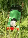
A short distance later I dropped down to the stream to rescue a toy Percy the Small Engine from the water. We left him a few metres further on keeping watch from the grass. I wonder how far he's travelled in this manner - all the way from Inverness at the other end of the glen, perhaps?
Sunday, 18 May 2008
Fort William and Glen Coe , Munros
The Ben
Distance: 10.5 miles
Ascent: 1233 metres
Duration: 6 hours 7 minutes
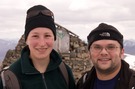
Walk 28 / M001: Ben Nevis / Beinn Nibheis
First of all, don't be fooled by the timing above. We may have been moving for just a little over six hours, but the entire day's walk including breaks took half as long again. The walk up took four and a quarter hours; the return trip four and a half.
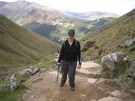
We didn't intend to climb the mountain today. After all we've done very little walking in recent months. Nevertheless the view from our bed towards Ben Nevis was perfectly clear so we decided to set out from Achintee on the Pony Path with the goal of only going as far as the halfway lochan as a warm-up to the week. That first part of the path really is very good. It's steep, but the walking is relatively easy on large stone slabs.
We knew that the character of the path would change at Lochan Meall an t-Suidhe. Looking ahead we saw a much more uneven way, strewn with loose, sharp stones. It took us ten minutes to make our mind up. The weather was clear, and we still felt pretty fit: we'd head out for the summit, taking it one leg of the zig-zags at a time, agreeing that if either of us wanted to turn back then we would, without hesitation or comment.
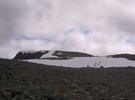
The man at the Visitor Centre had warned us there'd be snow on the summit plateau, and an hour and a half later we got a clear view of it. This was the moment it became clear to me that we'd reach the top. I led us straight across a patch of snow on McLean's Steep, not noticing that this was in fact the steeper direct route and that the zig-zags continued to the south. Still, once that was conquered the summit buildings were in sight, just across the deep snowy plateau.
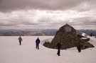
Unlike on Snowdon where passing walkers encourage each other all the way ("You're almost there!", "You'll make it!"), on the Ben there was a reverent silence, just a nod which combined encouragement, respect and warning. At the summit that silence broke and the pent-up congratulations flowed.
We stayed just quarter of an hour at the top: enough time to eat lunch, take a few photos and make the odd phone call. It was tempting to stay for longer, but it was too cold and we had one eye on the time we were due to check in at the bottom.
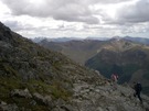
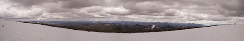
The view was spectacular. Although there were clouds overhead, none were below us and there were a multitude of other summits to identify. To the north we saw the Cuillin. To the south, the Mamores and the mountains of Glen Coe.
The walk back down was slower. For one thing we'd not taken many photographs on the ascent so we stopped more frequently on the descent. For another Emma's knee started playing up about quarter of the way down so each painful step was taken with care.
Finally we reached Achintee again, nine hours after we left. Launching straight into climbing Ben Nevis on the first day of our holiday may mean our bodies will seize up tomorrow and rule out any more walking all week, but I've not a single regret we did it.
Friday, 16 May 2008
Personal
The other Millennium Wheel
Forget the one down south. This is the more impressive Millennium Wheel.
The Falkirk Wheel is British engineering at its best. Preposterous, provocative, ingenious, striking and elegant. From afar it looks like a child's toy. It's only when you get close that you appreciate how graceful it is.
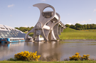
If you can't quite see what happens, it might help to know this is a boat lift - a modern canal lock. A barge moves into the chamber at the bottom of the structure, then the front part rotates (it's already rotated about ten degrees in this picture), swapping the positions of the top and bottom chambers. Once at the top the barge moves forwards out of the chamber, onto the aqueduct and away.
Because it's balanced, the entire structure takes just 18kW to operate, lifts boats 20 metres in 15 minutes and loses only a cupful of water per turn. Apparently the old lock staircase took hours to traverse.
We drove for seven hours today. It feels as if we've our destination is a different millennium.
Wednesday, 14 May 2008
Sunday, 11 May 2008
The Ridgeway
Wendover → Ivinghoe Beacon
Distance: 11.9 miles
Ascent: 263 metres
Duration: 4 hours
The end
« Not walked | Not walked »
Nature did its best to prevent our completion of this walk today but we battled on regardless.
Shortly after leaving Wendover the Trail enters Barn Wood where we soon lost sight of the familiar acorn sign-posts, heading too far uphill trying to find the sweeping path our guide book referred to. We picked up the path again a few hundred metres further on, but it wasn't a good start to the day.
It was only once out of the wood that we realised how blisteringly hot the day was becoming. Thus the pattern for the walk was set: shelter and sunburn in equal measures.
Ivinghoe Beacon felt like a disappointment in some ways. It's clearly a well-loved open space, but other than the end-of-trail notice board it didn't feel like a destination. (Maybe I'm just bitter that we couldn't find the much anticipated ice-cream van.)
We sat for half an hour enjoying the view before making our way down through the meadow to the bus stop below.
Saturday, 10 May 2008
The Ridgeway
Princes Risborough → Wendover
Distance: 5.99 miles
Ascent: 224 metres
Duration: 2 hours 7 minutes
A bigger house
« Not walked | Not walked »
Such a contrast to the previous walk! Last weekend we passed a tiny dwelling from my past; today we passed something much grander, somewhere I've never been before: Chequers.
Although the house remains largely hidden from view, its presence in the countryside is clear. A kilometre or so away we started seeing the ominous signs: "Trespass on this site is a criminal offence". Children on leads, then!
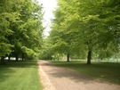
Most of the rest of the walk was through woodland, with the bluebells out in force.
We ended in Wendover, which looks to be a lovely town. Once again the decision to stop was pragmatic rather than because we didn't have the energy to continue. Hopefully we'll be back tomorrow, to complete the remainder of the Trail in one day and get a bus back to the car without having to resort to taxis.
Sunday, 4 May 2008
The Ridgeway
Kingston Blount → Princes Risborough
Distance: 6.21 miles
Ascent: 84 metres
Duration: 2 hours 3 minutes
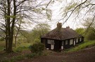
Warren Cottage
« Not walked | Not walked »
When I was in primary school my parents ran the Icthyans youth group at our church in Chorleywood. Another member of the congregation owned a small cottage in the Chilterns, so every now and then the youth group would have a weekend away.
My memories of those weekends in the '70s are still quite clear. We'd have to leave the car at a bend in the road and walk a mile up a wooded track to get to Warren Cottage. The cottage had no mains utilities: water was heated on a stove and washing was al fresco with water drawn from the well. We'd go walking in the woods to collect firewood and stumble across the chalk cross.
I mention all this because the wooded track forms part of the Ridgeway so we walked past the cottage today, just south of Bledlow on Wain Hill. I understand it is now connected to mains utilities and a manhole cover hides the old well, but it's unmistakably the same place.