Saturday, 5 January 2008
The Ridgeway
Mongewell → Watlington
Distance: 10.0 miles
Ascent: 433 metres
Duration: 3 hours 13 minutes
Uphill again
« Not walked | Not walked »
It's time for The Ridgeway National Trail to head away from the river and pick up the route of an ancient track again.
From Mongewell the walk to Nuffield follows an embankment marked on maps as Grim's Ditch. This is a very pleasant section, particularly with the strong winter light on the trees that line the way.
After crossing the main road in Nuffield the path dives back into woodland, weaving its way through fields and estates before finally meeting the old track just south-east of Britwell Salome.
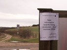
All along the route last year we saw large empty notice boards. Attached to them were A4 laminated posters declaring that new boards were being produced for summer 2007. Today we saw that these laminates - if not the information boards themselves - have been updated. I wonder whether next year the content will still be missing but supplemented with a promise of something new in summer 2009.